Maskowski District
Jump to navigation
Jump to search
Maskowski (Маскоўскі) | |
|---|---|
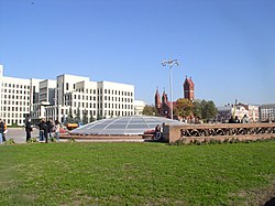
 Independence Square | |
|
Coat of arms | |
 | |
| Country | |
| Voblast | |
| Municipality | |
| Government | |
| • Local governor | Dukor Evgeny Michailovich |
| Area | |
| • Total | 30 km2 (10 sq mi) |
| Population (2009) | 270,240 |
| • Density | 9,008/km2 (23,330/sq mi) |
| District number | 8 |
| Website | Official website |
Maskowski District (Belarusian: Маскоўскі; Russian: Московский) is an administrative subdivision of the city of Minsk, Belarus. It was named after the city of Moscow.[1]
Geography
The district is situated in central and south-western area of the city and borders with Frunzyenski, Tsentralny, Leninsky and Kastrychnitski districts.
Transport
Maskowski is served by the subway and tram networks. It is also crossed by the MKAD beltway.
See also
References
- ^ (in Russian) Moskovsky Raion Archived 2005-11-02 at the Wayback Machine, Minsk administration website
External links
- (in Russian) Maskowski District official website
- (in Russian) Maskowski District on Minsk website
Categories:
- Articles with Russian-language sources (ru)
- Webarchive template wayback links
- Articles with short description
- Short description with empty Wikidata description
- Pages using infobox settlement with bad settlement type
- Pages using infobox settlement with no coordinates
- Articles containing Belarusian-language text
- Articles containing Russian-language text
- Coordinates not on Wikidata
- Districts of Minsk
- All stub articles
- Belarus geography stubs