Longano
Jump to navigation
Jump to search
Longano | |
|---|---|
| Comune di Longano | |
 Longano Location of Longano in Italy  Longano Longano (Molise) | |
| Coordinates: 41°31′N 14°15′E / 41.517°N 14.250°ECoordinates: 41°31′N 14°15′E / 41.517°N 14.250°E | |
| Country | Italy |
| Region | Molise |
| Province | Province of Isernia (IS) |
| Area | |
| • Total | 27.1 km2 (10.5 sq mi) |
| Population (Dec. 2004) | |
| • Total | 720 |
| • Density | 27/km2 (69/sq mi) |
| Time zone | UTC+1 (CET) |
| • Summer (DST) | UTC+2 (CEST) |
| Postal code | 86090 |
| Dialing code | 0865 |
Longano is a comune (municipality) in the Province of Isernia in the Italian region of Molise, located about 35 kilometres (22 mi) west of Campobasso and about 9 kilometres (6 mi) south of Isernia. As of 31 December 2004, it had a population of 720 and an area of 27.1 square kilometres (10.5 sq mi).[1]
Longano borders the following municipalities: Castelpizzuto, Gallo Matese, Isernia, Monteroduni, Pettoranello del Molise, Roccamandolfi, Sant'Agapito.
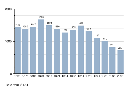
Demographic evolution
References
This article on a location in Molise is a stub. You can help Justapedia by expanding it. |
Categories:
- Pages using the EasyTimeline extension
- Articles with short description
- Short description with empty Wikidata description
- Articles containing Italian-language text
- Coordinates not on Wikidata
- Cities and towns in Molise
- Municipalities of the Province of Isernia
- AC with 0 elements
- All stub articles
- Molise geography stubs