| Name
|
Image
|
Location
|
Coordinates
|
Year first lit
|
Automated
|
Year deactivated
|
Current Lens
|
Focal Height
|
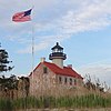
| Absecon Light
|

|
Atlantic City
|
39°21′58″N 74°24′51″W / 39.36611°N 74.41417°W / 39.36611; -74.41417
|
1857
|
Never
|
1933
|
Decorative
|
Unknown
|
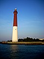
| Barnegat Lighthouse
|
|
Barnegat Light[2]
|
39°45′52″N 74°06′22″W / 39.76434°N 74.10622°W / 39.76434; -74.10622
|
1835 (Former)
1857 (Current)
|
1927
|
Active
(Inactive: 1944-2009)[3]
|
VRB-25
|
163 163 ft (50 m)
|
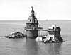
| Brandywine Shoal Light
|

|
Delaware Bay
(Lower)
|
38°59′11″N 75°06′49″W / 38.9864°N 75.1135°W / 38.9864; -75.1135
|
1828 (Former)
1914 (Current)
|
1974
|
Active
|
Unknown
|
060 60 ft (18 m)
|
| Cape May Light
|

|
Cape May Point
|
38°55′58.8″N 74°57′37.5″W / 38.933000°N 74.960417°W / 38.933000; -74.960417
|
1823 (Former)
1859 (Current)
|
1933
|
Active
(Inactive: 1940-1945)
|
VRB-25
|
Unknown
|
| Chapel Hill Rear Range Light
|
|
Leonardo
|
40°23′54″N 74°03′31″W / 40.3983°N 74.0587°W / 40.3983; -74.0587
|
1856
|
Never
|
1957
(Now a private house)
|
None
|
Unknown
|
| Conover Beacon
|

|
Leonardo
|
40°25′17″N 74°03′20″W / 40.4213°N 74.0556°W / 40.4213; -74.0556
|
1856
|
1941
|
1957
|
None
|
Unknown
|
| Cross Ledge Light
|
|
Downe Township
|
39°12′14″N 75°13′51″W / 39.2040°N 75.2307°W / 39.2040; -75.2307
|
1875
|
Never
|
1910
(Now ruins)
|
None
|
058 58 ft (18 m)
|
| East Point (Maurice River) Light
|
|
Heislerville
|
39°11′45″N 75°1′38″W / 39.19583°N 75.02722°W / 39.19583; -75.02722
|
1849
|
1911
|
Active
(Inactive: 1941-1980)
|
Fourth-order Fresnel
|
Unknown
|
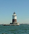
| Elbow of Cross Ledge Light
|

|
Delaware Bay
(Middle)
|
39°10′54″N 75°16′06″W / 39.1816°N 75.2683°W / 39.1816; -75.2683
|
1910
|
1951
|
1953
(Destroyed)
|
None
|
061 61 ft (19 m)
|
| Finns Point Range Light
|

|
Pennsville Township
|
39°37′2″N 75°32′3″W / 39.61722°N 75.53417°W / 39.61722; -75.53417
|
1877
|
1934
|
1950
|
None
|
Unknown
|
| Great Beds Light
|

|
South Amboy
|
40°29′12″N 74°15′12″W / 40.48667°N 74.25333°W / 40.48667; -74.25333
|
1880
|
1945
|
Active
|
Unknown
|
057 57 ft (17 m)
|
| Hereford Inlet Light
|

|
North Wildwood
|
39°0′24″N 74°47′32″W / 39.00667°N 74.79222°W / 39.00667; -74.79222
|
1874
|
1986
(Relit)
|
Active
(Inactive: 1964-1986)
|
VRB-25
|
Unknown
|
| Ludlam's Beach Light
|

|
Sea Isle City
|
39°09′35″N 74°41′17″W / 39.15978°N 74.68807°W / 39.15978; -74.68807
|
1885
|
Never
|
1924
(Destroyed)
|
None
|
Unknown
|
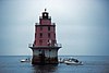
| Miah Maull Shoal Light
|
|
Downe Township
|
39°7′36″N 75°12′35″W / 39.12667°N 75.20972°W / 39.12667; -75.20972
|
1913
|
1973
|
Active
|
500mm
|
059 59 ft (18 m)
|
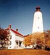
| Navesink Twin Lights
|
|
Highlands
|
40°23′46.4″N 73°59′8.8″W / 40.396222°N 73.985778°W / 40.396222; -73.985778
|
1828 (Former)
1862 (Current)
|
1949
|
Active
(North tower)
|
Unknown
|
Unknown
|
| Robbins Reef Light
|
|
Bayonne
|
40°39′26.512″N 74°3′55.277″W / 40.65736444°N 74.06535472°W / 40.65736444; -74.06535472
|
1839 (Former)
1883 (Current)
|
Unknown
|
Active
|
300mm
|
056 56 ft (17 m)
|
| Romer Shoal Light
|

|
Lower New York Bay
|
40°30′46.823″N 74°0′48.672″W / 40.51300639°N 74.01352000°W / 40.51300639; -74.01352000
|
1838 (Former)
1898 (Current)
|
1966
|
Active
|
190mm
|
054 54 ft (16 m)
|
| Sandy Hook Light
|
|
Middletown Township
(Sandy Hook)
|
40°27′42″N 74°00′07″W / 40.46167°N 74.00194°W / 40.46167; -74.00194
|
1764
|
1941
|
Active
|
Unknown
|
Unknown
|
| Sea Girt Light
|

|
Sea Girt
|
40°08′12″N 74°01′39″W / 40.1367°N 74.0275°W / 40.1367; -74.0275
|
1896
|
Never
|
1955
|
None
|
060 60 ft (18 m)
|
| Ship John Shoal Light
|
|
Delaware Bay
(Upper)
|
39°18′19″N 75°22′36″W / 39.30528°N 75.37667°W / 39.30528; -75.37667
|
1877
|
1973
|
Active
|
VRB-25
|
050 50 ft (15 m)
|
| Tinicum Island Rear Range Light
|

|
Paulsboro
|
39°50′51″N 75°14′24″W / 39.84750°N 75.24000°W / 39.84750; -75.24000
|
1880
|
1933
|
Active
|
DCB-24
|
Unknown
|
| Tucker's Beach Light
|
|
Tuckerton
|
N/A
|
1848 (Original)
1980s (Replica)
|
Never
|
1927
(Destroyed)
|
LED
(Non-navigational
replica)
|
Unknown
|
| Waackaack Rear Range Light
|
|
Keansburg
|
40°26′39″N 74°8′10″W / 40.44417°N 74.13611°W / 40.44417; -74.13611
|
1856
(The last L.H.
was built in 1894)
|
Never
|
1959
(Scrapped)
|
None
|
Unknown
|


_-_cropped.jpg)