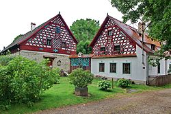
Lipová (Cheb District)
Lipová | |
|---|---|
 Traditional timber farm | |
| Coordinates: 50°2′11″N 12°26′56″E / 50.03639°N 12.44889°ECoordinates: 50°2′11″N 12°26′56″E / 50.03639°N 12.44889°E | |
| Country | |
| Region | Karlovy Vary |
| District | Cheb |
| First mentioned | 1785 |
| Area | |
| • Total | 45.76 km2 (17.67 sq mi) |
| Elevation | 506 m (1,660 ft) |
| Population (2022-01-01)[1] | |
| • Total | 708 |
| • Density | 15/km2 (40/sq mi) |
| Time zone | UTC+1 (CET) |
| • Summer (DST) | UTC+2 (CEST) |
| Postal code | 350 02 |
| Website | www |
Lipová (German: Lindenhau) is a municipality and village in Cheb District in the Karlovy Vary Region of the Czech Republic. It has about 700 inhabitants.
Administrative parts
Villages of Dolní Lažany, Dolní Lipina, Doubrava, Horní Lažany, Mechová, Mýtina, Palič and Stebnice are administrative parts of Lipová.
Geography
Lipová is located about 6 km (4 mi) southeast of Cheb, on the border with Germany.
The northern part of the municipality lies in the Cheb Basin, the southern part extends into the Fichtel Mountains and the southeastern part into the Upper Palatine Forest. The highest point is located on the southeastern municipal border, on the slopes of the Dyleň mountain, at about 825 m (2,707 ft). Near the village of Mýtina there is the Železná hůrka National Nature Monument with an extinct Quaternary volcano.
References
- Articles with short description
- Short description with empty Wikidata description
- Coordinates not on Wikidata
- Articles containing German-language text
- Commons category link is defined as the pagename
- Populated places in Cheb District
- AC with 0 elements
- Villages in Cheb District
- All stub articles
- Karlovy Vary Region geography stubs


