Lety (Písek District)
Jump to navigation
Jump to search
Lety | |
|---|---|
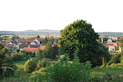
 View of a part of Lety | |
| Coordinates: 49°31′1″N 14°5′16″E / 49.51694°N 14.08778°ECoordinates: 49°31′1″N 14°5′16″E / 49.51694°N 14.08778°E | |
| Country | |
| Region | South Bohemian |
| District | Písek |
| First mentioned | 1312 |
| Area | |
| • Total | 13.91 km2 (5.37 sq mi) |
| Elevation | 450 m (1,480 ft) |
| Population (2022-01-01)[1] | |
| • Total | 279 |
| • Density | 20/km2 (52/sq mi) |
| Time zone | UTC+1 (CET) |
| • Summer (DST) | UTC+2 (CEST) |
| Postal code | 398 07 |
| Website | www |
Lety is a municipality and village in Písek District in the South Bohemian Region of the Czech Republic. It has about 300 inhabitants.
Administrative parts
The village of Šerkov and the hamlet of Pukňov are administrative parts of Lety.
Geography
Lety is located about 24 kilometres (15 mi) north of Písek and 60 km (37 mi) south of Prague. It lies in the Benešov Uplands. The highest point is the hill Holý vrch at 541 metres (1,775 ft) above sea level.
History
The first written mention of Lety is from 1312.[2]
During the World War II, the Lety concentration camp was established in the municipality. Romani people were the largest group interned in the camp.
References
- ^ "Population of Municipalities – 1 January 2022". Czech Statistical Office. 2022-04-29.
- ^ "Historie obce" (in Czech). Obec Lety. Retrieved 2022-08-01.
External links
Wikimedia Commons has media related to Lety (Písek District).
