Lentiai
Jump to navigation
Jump to search
Lentiai | |
|---|---|
| Comune di Lentiai | |
 Piazza Crivellaro | |
 Lentiai Location of Lentiai in Italy  Lentiai Lentiai (Veneto) | |
| Coordinates: 46°3′N 12°1′E / 46.050°N 12.017°ECoordinates: 46°3′N 12°1′E / 46.050°N 12.017°E | |
| Country | Italy |
| Region | Veneto |
| Province | Province of Belluno (BL) |
| Government | |
| • Mayor | Dott. Flavio Tremea |
| Area | |
| • Total | 37.6 km2 (14.5 sq mi) |
| Population (Dec. 2004) | |
| • Total | 3,020 |
| • Density | 80/km2 (210/sq mi) |
| Time zone | UTC+1 (CET) |
| • Summer (DST) | UTC+2 (CEST) |
| Postal code | 32020 |
| Dialing code | 0437 |
| Website | http://www.comune.lentiai.bl.it/ |
Lentiai is a comune (municipality) in the province of Belluno in the Italian region of Veneto, located about 70 kilometres (43 mi) northwest of Venice and about 20 kilometres (12 mi) southwest of Belluno. As of 31 December 2004, it had a population of 3,020 and an area of 37.6 square kilometres (14.5 sq mi).[1]
Lentiai borders the following municipalities: Cesiomaggiore, Feltre, Mel, Santa Giustina, Valdobbiadene, Vas.
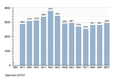
Demographic evolution
References
This article on a location in Veneto is a stub. You can help Justapedia by expanding it. |
Categories:
- Pages using the EasyTimeline extension
- Articles with short description
- Short description with empty Wikidata description
- Articles containing Italian-language text
- Coordinates not on Wikidata
- Cities and towns in Veneto
- Municipalities of the Province of Belluno
- AC with 0 elements
- All stub articles
- Veneto geography stubs