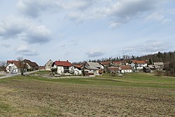
Laze, Logatec
Jump to navigation
Jump to search
Laze | |
|---|---|
 | |
| Coordinates: 45°51′31.7″N 14°15′53.21″E / 45.858806°N 14.2647806°ECoordinates: 45°51′31.7″N 14°15′53.21″E / 45.858806°N 14.2647806°E | |
| Country | |
| Traditional region | Inner Carniola |
| Statistical region | Central Slovenia |
| Municipality | Logatec |
| Area | |
| • Total | 11.56 km2 (4.46 sq mi) |
| Elevation | 453.5 m (1,487.9 ft) |
| Population (2002) | |
| • Total | 299 |
| [1] | |
Laze (pronounced [ˈlaːzɛ], German: Lase[2]) is a village south of Logatec in the Inner Carniola region of Slovenia.[3]
Unmarked grave
Laze is the site of an unmarked grave from the period after the Second World War. The Logarček Shaft Grave (Slovene: Grobišče Brezno Logarček) is located in the woods between Laze and the freeway, about 320 meters (1,050 ft) northwest of the overpass. It contained the remains of a Slovene civilian victim of the December 1945 postwar killings. The remains were removed from the grave under unknown circumstances.[4]
References
- ^ Statistical Office of the Republic of Slovenia
- ^ Leksikon občin kraljestev in dežel zastopanih v državnem zboru, vol. 6: Kranjsko. Vienna: C. Kr. Dvorna in Državna Tiskarna. 1906. p. 128.
- ^ Logatec municipal site
- ^ Ferenc, Mitja (December 2009). "Grobišče Brezno Logarček". Geopedia (in Slovenian). Ljubljana: Služba za vojna grobišča, Ministrstvo za delo, družino in socialne zadeve. Retrieved April 22, 2020.
External links
 Media related to Laze at Wikimedia Commons
- Laze on Geopedia
Categories:
- CS1 Slovenian-language sources (sl)
- Articles with short description
- Short description with empty Wikidata description
- Coordinates not on Wikidata
- Articles containing German-language text
- Articles containing Slovene-language text
- Commons category link is defined as the pagename
- Populated places in the Municipality of Logatec
- All stub articles
- Osrednjeslovenska statistical region geography stubs

