Lake Taymyr
This article includes a list of general references, but it lacks sufficient corresponding inline citations. (January 2012) |
| Lake Taymyr | |
|---|---|
 Location of Lake Taymyr in the center of the Taymyr Peninsula | |
 Lake Taymyr | |
| Location | Taymyr Peninsula, Taymyrsky Dolgano-Nenetsky District, Krasnoyarsk Krai, Russia |
| Coordinates | 74°32′34″N 101°38′39″E / 74.54278°N 101.64417°ECoordinates: 74°32′34″N 101°38′39″E / 74.54278°N 101.64417°E |
| Primary inflows | Zapadnaya, Severnaya, Bikada-Nguoma, Yamu-Tarida, Kalamissamo, Upper Taymyra |
| Primary outflows | Lower Taymyra |
| Catchment area | 104,300 km2 (40,300 sq mi) [1] |
| Basin countries | Russia |
| Max. length | 204 km (127 mi) [2] |
| Max. width | 154 km (96 mi) [2] |
| Surface area | 4,560 km2 (1,760 sq mi) [3] |
| Average depth | 2.8 m (9.2 ft) [3] |
| Max. depth | 26 m (85 ft) [3] |
| Water volume | 12.8 km3 (3.1 cu mi) |
| Surface elevation | 6 m (20 ft) [3] |
| Frozen | late September until June |
| Islands | 20 |
| Settlements | none |
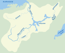
Lake Taymyr (Russian: Таймы́р, Таймы́рское о́зеро) is a lake of the central regions of the Taymyr Peninsula in Krasnoyarsk Krai, Russian Federation. It is located south of the Byrranga Mountains.
Geography
Lake Taymyr is large, with a length of 165 km roughly east-to-west. It has an irregular shape with many arms projecting in different directions that cover a wide region. Its maximum width, however, is only about 23 km in its broadest area which is towards the eastern end of the lake.
Lake Taymyr is covered with ice from late September until June. The main river flowing into its basin, from the west, is the Upper Taymyra. Other rivers flowing into it are the Zapadnaya, Severnaya, Bikada-Nguoma, Yamu-Tarida and Kalamissamo. The Lower Taymyra flows out of the lake northwards across the Byrranga mountain region.
The tundra areas south of Lake Taymyr are full of smaller lakes and marshes. There are two quite large lakes east and southeast of the easternmost part of Lake Taymyr, which is Yamuneru Bay: 33 km east is Lake Kungusalakh, and 72 km southeast is Lake Portnyagino. Both lakes are about 20 km across.
Ecology
Lake Taymyr is teeming with many kinds of fish typical of cold Arctic waters, like loach, sig, and muksun. But there is overexploitation of some fish species despite the remoteness of the area.[4]
Slight plutonium contamination has been detected in the sediments of Lake Taymyr. This is perhaps a consequence of wind-carried particles after the numerous atmospheric nuclear tests in Novaya Zemlya during the Cold War.
Water temperatures
- Average water temperature in August: +7 °C
- During winter, water temperature is slightly above 1 °C
- Lake Taymyr
Catchment Area
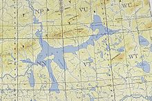
Lake Taymyr. US military map 1964 г.


References
- ^ Ministry for Natural Resources of the Russian Federation: Physico-geographical conditions of the Taimyr Reserve Archived 2005-02-22 at the Wayback Machine
- ^ a b measured from satellite image
- ^ a b c d Таймыр (озеро) (Lake Taymyr) in the Great Soviet Encyclopedia, 1969–1978 (in Russian)
- ^ Overexploitation of some fish species
External links
- Webarchive template wayback links
- Articles with short description
- Short description with empty Wikidata description
- Articles lacking in-text citations from January 2012
- All articles lacking in-text citations
- Coordinates not on Wikidata
- Articles using infobox body of water without alt
- Articles using infobox body of water without pushpin map alt
- Articles using infobox body of water without image bathymetry
- Articles containing Russian-language text
- Commons category link is the pagename
- Biosphere reserves of Russia
- Lakes of Krasnoyarsk Krai
- North Siberian Lowland