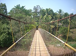
Kooveri
Kooveri
Koovery | |
|---|---|
village | |
 Kooveri Suspension Bridge | |
| Coordinates: 12°06′34″N 75°23′39″E / 12.10938°N 75.39413°ECoordinates: 12°06′34″N 75°23′39″E / 12.10938°N 75.39413°E | |
| Country | |
| State | Kerala |
| District | Kannur |
| Government | |
| • Body | Chapparapadavu Grama Panchayat |
| Area | |
| • Total | 38.32 km2 (14.80 sq mi) |
| Population (2011) | |
| • Total | 19,033 |
| • Density | 500/km2 (1,300/sq mi) |
| Languages | |
| • Official | Malayalam, English |
| Time zone | UTC+5:30 (IST) |
| PIN | 670581 |
| Vehicle registration | KL 59 |
| Nearest city | Taliparamba |
| Lok Sabha constituency | Kannur |
| Vidhan Sabha constituency | Taliparamba |
Kooveri is a village in Chapparapadavu Grama Panchayat of Kannur district in the Indian state of Kerala.[1]
Demographics
As of 2011[update] India census, Kooveri had a population of 19,033 with 9,111 (47.9%) males and 9,922 (52.1%) females. Kooveri village have an area of 38.32 km2 with 4,201 families residing in it. Average sex ratio was 1089 higher than the state average of 1084. In Kooveri, 11.3% of the population was under 6 years of age. Kooveri had an average literacy of 91.7% lower than the state average of 94%; male literacy was 95.9% and female literacy was 87.9%.[2]
Administration
Kooveri village is a part of Chapparapadavu Grama Panchayat in Taliparamba Block Panchayat. Kooveri is politically part of Taliparamba (State Assembly constituency) under Kannur Loksabha.[3]
References
- ^ "Population data - Villages with population 5000 & above". www.censusindia.gov.in. Archived from the original on 8 December 2008. Retrieved 12 January 2022.
- ^ "Census of India - 2011 - Kooveri". Retrieved 13 September 2021.
- ^ "Assembly Constituencies - Corresponding Districts and Parliamentary Constituencies" (PDF). Kerala. Election Commission of India. Archived from the original (PDF) on 2009-03-04. Retrieved 2008-10-18.
