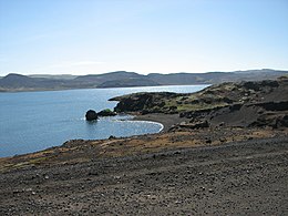
Kleifarvatn
Jump to navigation
Jump to search
This article needs additional citations for verification. (May 2021) |
| Kleifarvatn | |
|---|---|
 Lake Kleifarvatn in Iceland | |
| Location | Reykjanes |
| Coordinates | 63°55′30″N 21°58′48″W / 63.92500°N 21.98000°WCoordinates: 63°55′30″N 21°58′48″W / 63.92500°N 21.98000°W |
| Basin countries | Iceland |
| Max. length | 4.7 km (2.9 mi) |
| Max. width | 2.5 km (1.6 mi) |
| Surface area | 8 km2 (3.1 sq mi) |
| Max. depth | 97 m (318 ft) (as of 2000[update]) |
Kleifarvatn (Icelandic pronunciation: [ˈkʰleiːvarˌvahtn̥]) is the largest lake on the Reykjanes Peninsula in Iceland, situated in the southern part of the peninsula. It is located on the fissure zone of the Mid-Atlantic Ridge. The lake has no visible water coming in or going out as most of its water comes and leaves underground.[1] The lake can be reached via a track, and there are two areas with high temperature that can be found not far from it: Seltún/Krýsuvík and another to the east. The lake's greatest depth is 97 m. After the 2000 Iceland earthquakes, the lake began to diminish, and 20% of its surface has since disappeared.
The novel Kleifarvatn by Icelandic writer Arnaldur Indriðason was named after the lake.
See also
References
- ^ "Lake Kleifarvatn". Hit Iceland. Retrieved 5 July 2016.
External links
- Photos
- More information and photos about Kleifarvatn on Hit Iceland
- Kleifarvatn – Photo gallery
- "Iceland Lake Disappearing Into New Crack in Earth", Bijal P. Trivedi, National Geographic Today, October 1, 2001
Categories:
- Articles with short description
- Short description with empty Wikidata description
- Articles needing additional references from May 2021
- All articles needing additional references
- Use dmy dates from December 2013
- Coordinates not on Wikidata
- Articles containing potentially dated statements from 2000
- All articles containing potentially dated statements
- Articles using infobox body of water without alt
- Articles using infobox body of water without image bathymetry
- AC with 0 elements
- Krýsuvík Volcanic System
- Lakes of Iceland
- Reykjanes
- Rift lakes of Iceland
- All stub articles
- Iceland geography stubs

