Klecany
Jump to navigation
Jump to search
Klecany | |
|---|---|
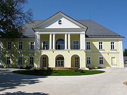
 Klecany Château | |
| Coordinates: 50°10′30″N 14°25′0″E / 50.17500°N 14.41667°ECoordinates: 50°10′30″N 14°25′0″E / 50.17500°N 14.41667°E | |
| Country | |
| Region | Central Bohemian |
| District | Prague-East |
| First mentioned | 1316 |
| Government | |
| • Mayor | Daniel Dvořák |
| Area | |
| • Total | 10.16 km2 (3.92 sq mi) |
| Elevation | 265 m (869 ft) |
| Population (2022-01-01)[1] | |
| • Total | 3,601 |
| • Density | 350/km2 (920/sq mi) |
| Time zone | UTC+1 (CET) |
| • Summer (DST) | UTC+2 (CEST) |
| Postal code | 250 67 |
| Website | www |
Klecany is a town in Prague-East District in the Central Bohemian Region of the Czech Republic. It has about 3,600 inhabitants.
Administrative parts
Villages of Drasty, Klecánky and Zdibsko are administrative parts of Klecany.
Geography
Klecany lies about 5 kilometres (3 mi) north of Prague. The municipality is located in the Prague Plateau, on the right bank of the Vltava River.
History
The first written mention of Klecany is from 1316. In 1507, it was promoted to a market town by King Vladislaus II. In 1994 it became a town.[2]
Notable people
- Václav Beneš Třebízský (1849–1884), writer; worked here as a chaplain in 1876–1884
References
- ^ "Population of Municipalities – 1 January 2022". Czech Statistical Office. 2022-04-29.
- ^ "Z historie Klecan" (in Czech). Město Klecany. Retrieved 2021-06-21.
External links
Wikimedia Commons has media related to Klecany.
Categories:
- CS1 Czech-language sources (cs)
- Articles with short description
- Short description with empty Wikidata description
- Coordinates not on Wikidata
- Commons category link is defined as the pagename
- Official website not in Wikidata
- Populated places in Prague-East District
- AC with 0 elements
- Cities and towns in the Czech Republic
- All stub articles
- Central Bohemian Region geography stubs


