Khalilabad County
Jump to navigation
Jump to search
Khalilabad County
شهرستان خليل آباد | |
|---|---|
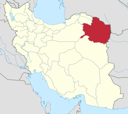
 Location of Khalilabad County in Razavi Khorasan province | |
 Location of Razavi Khorasan province in Iran | |
| Coordinates: 35°10′N 58°11′E / 35.167°N 58.183°ECoordinates: 35°10′N 58°11′E / 35.167°N 58.183°E | |
| Country | |
| Province | Razavi Khorasan |
| Capital | Khalilabad |
| Districts | 2 (2006) |
| Population (2016) | |
| • Total | 51,701 |
| Time zone | UTC+3:30 (IRST) |
| • Summer (DST) | UTC+4:30 (IRDT) |
| Khalilabad County at GEOnet Names Server | |
Khalilabad County (Persian: شهرستان خليل آباد) is located in Razavi Khorasan province, Iran. The capital of the county is Khalilabad. At the 2006 census, the county's population was 44,993, in 12,298 families.[1] At the 2016 census, the county's population was 51,701.[2]
Administrative divisions
| Administrative Divisions | Pop. |
|---|---|
| Central District | 26,770 |
| Howmeh Rural District | 10,231 |
| Rostaq Rural District | 8,130 |
| Khalilabad City | 8,409 |
| Sheshtaraz District | 18,223 |
| Kavir Rural District | 6,171 |
| Sheshtaraz Rural District | 6,352 |
| Kondor City | 5,700 |
| Total Khalilabad County | 44,993 |
References
- ^ a b "Census of the Islamic Republic of Iran, 1385 (2006)" (Excel). Statistical Center of Iran. Archived from the original on 2011-11-11.
- ^ "Census of the Islamic Republic of Iran, 1395 (2016)" (Excel). Islamic Republic of Iran.
Wikimedia Commons has media related to Khalilabad County.
Categories:
- Articles with short description
- Short description with empty Wikidata description
- Coordinates not on Wikidata
- Articles containing Persian-language text
- Khalilabad County
- Counties of Razavi Khorasan Province
- Commons category link is defined as the pagename
- All stub articles
- Razavi Khorasan Province geography stubs
