Kamenná (Šumperk District)
Jump to navigation
Jump to search
Kamenná | |
|---|---|
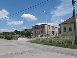
 Centre of Kamenná | |
| Coordinates: 49°51′34″N 17°1′52″E / 49.85944°N 17.03111°ECoordinates: 49°51′34″N 17°1′52″E / 49.85944°N 17.03111°E | |
| Country | |
| Region | Olomouc |
| District | Šumperk |
| First mentioned | 1385 |
| Area | |
| • Total | 5.12 km2 (1.98 sq mi) |
| Elevation | 386 m (1,266 ft) |
| Population (2022-01-01)[1] | |
| • Total | 521 |
| • Density | 100/km2 (260/sq mi) |
| Time zone | UTC+1 (CET) |
| • Summer (DST) | UTC+2 (CEST) |
| Postal codes | 789 74 |
| Website | www |
Kamenná (German: Steine) is a municipality and village in Šumperk District in the Olomouc Region of the Czech Republic. It has about 500 inhabitants.
Kamenná lies approximately 13 kilometres (8 mi) south of Šumperk, 34 km (21 mi) north-west of Olomouc, and 189 km (117 mi) east of Prague.
References
Wikimedia Commons has media related to Kamenná (Šumperk District).


