Horqin District
Horqin
科尔沁区 • ᠬᠣᠷᠴᠢᠨᠲᠣᠭᠣᠷᠢᠭ | |
|---|---|
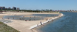
 Liaohe River Park under Construction | |
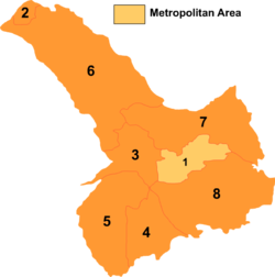
 Tongliao divisions: Horqin is 1 on this map | |
| Coordinates: 43°37′21″N 122°15′21″E / 43.62250°N 122.25583°ECoordinates: 43°37′21″N 122°15′21″E / 43.62250°N 122.25583°E | |
| Country | People's Republic of China |
| Region | Inner Mongolia |
| Prefecture-level city | Tongliao |
| Area | |
| • Total | 3,487 km2 (1,346 sq mi) |
| Elevation | 179 m (587 ft) |
| Population (2020)[1] | |
| • Total | 921,808 |
| • Density | 260/km2 (680/sq mi) |
| Time zone | UTC+8 (China Standard) |
| Horqin District | |||||||
|---|---|---|---|---|---|---|---|
| Chinese name | |||||||
| Simplified Chinese | 科尔沁区 | ||||||
| Traditional Chinese | 科爾沁區 | ||||||
| |||||||
| Mongolian name | |||||||
| Mongolian Cyrillic | Қорчин тоори | ||||||
| Mongolian script | ᠬᠣᠷᠴᠢᠨᠲᠣᠭᠣᠷᠢᠭ | ||||||
| |||||||
Horqin District (Mongolian script: ᠬᠣᠷᠴᠢᠨ ᠲᠣᠭᠣᠷᠢᠭ; Chinese: 科尔沁区) is an administrative district of the prefecture-level city of Tongliao, Inner Mongolia, China, and its seat of government.
The district was formed in January 1999 upon the creation of the prefecture-level city of Tongliao from the former Jirem League. The boundaries of the district is roughly coterminous with the core urban area of Tongliao.
The local Mongolian dialect spoken in the area is Khorchin Mongolian; most people in the district speak Mandarin Chinese (the most commonly spoken dialect is Northeastern Mandarin).
The Inner Mongolia University for the Nationalities is located in the district; it was founded in 2000 as an amalgamation of the Inner Mongolia Normal College of the Nationalities, the Mongol Medicine College of Inner Mongolia, and the Jirem College of Animal Husbandry.
See also
References
External links
- www.xzqh.org (in Chinese)
- Articles with short description
- Short description with empty Wikidata description
- Articles containing Chinese-language text
- Coordinates not on Wikidata
- Articles containing Mongolian-language text
- Articles with Chinese-language sources (zh)
- AC with 0 elements
- County-level divisions of Inner Mongolia
- Tongliao
- All stub articles
- Inner Mongolia geography stubs