Holcomb, Illinois
Holcomb, Illinois | |
|---|---|
 Holcomb, Illinois  Holcomb, Illinois | |
| Coordinates: 42°03′53″N 89°05′44″W / 42.06472°N 89.09556°WCoordinates: 42°03′53″N 89°05′44″W / 42.06472°N 89.09556°W | |
| Country | United States |
| State | Illinois |
| County | Ogle |
| Area | |
| • Total | 0.09 sq mi (0.23 km2) |
| • Land | 0.09 sq mi (0.23 km2) |
| • Water | 0.00 sq mi (0.00 km2) |
| Elevation | 840 ft (260 m) |
| Population (2020) | |
| • Total | 149 |
| • Density | 1,674.16/sq mi (648.09/km2) |
| Time zone | UTC-6 (Central (CST)) |
| • Summer (DST) | UTC-5 (CDT) |
| ZIP code | 61043 |
| Area code(s) | 815 & 779 |
| GNIS feature ID | 410374[2] |
Holcomb is an unincorporated community in Ogle County, Illinois, United States. Holcomb is 3 miles (4.8 km) south of Davis Junction. Holcomb has a post office with ZIP code 61043.[3] Holcomb was founded in 1876. It was named for William H. Holcomb (c. 1839–1908), General Manager of the Chicago and Iowa Railroad at the time. He was also the Superintendent of Transportation for the World's Columbian Exposition held in Chicago in 1893.
Demographics
| Historical population | |||
|---|---|---|---|
| Census | Pop. | %± | |
| 2020 | 149 | — | |
| U.S. Decennial Census[4] | |||
Gallery

The railroad sign for Holcomb. As viewed looking North

The Holcomb Post Office

The Holcomb State Bank

The Hueber Grain Elevators. As seen looking West. Can be seen throughout village.

The Original Holcomb Hotel & General Store. Now a residence.
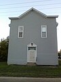
The Meridian Sun #505 Masonic Lodge
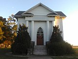
Former Church

The former Holcomb Carrie Sheaff School District 152 Building

The Holcomb Centennial Bell, erected in 1976
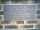
The plaque on the Centennial Bell


References
- ^ "2020 U.S. Gazetteer Files". United States Census Bureau. Retrieved March 15, 2022.
- ^ "US Board on Geographic Names". United States Geological Survey. 2007-10-25. Retrieved 2008-01-31.
- ^ ZIP Code Lookup
- ^ "Census of Population and Housing". Census.gov. Retrieved June 4, 2016.
Municipalities and communities of Ogle County, Illinois, United States | ||
|---|---|---|
| Cities | ||
| Villages | ||
| Townships | ||
| CDPs | ||
| Other communities | ||
| Footnotes | ‡This populated place also has portions in an adjacent county or counties | |
This Ogle County, Illinois location article is a stub. You can help Justapedia by expanding it. |
- Articles with short description
- Short description with empty Wikidata description
- Coordinates not on Wikidata
- Pages using infobox settlement with possible area code list
- AC with 0 elements
- 1876 establishments in Illinois
- Unincorporated communities in Ogle County, Illinois
- Unincorporated communities in Illinois
- All stub articles
- Rockford-Freeport-Rochelle geography stubs