Heinersreuth
Jump to navigation
Jump to search
Heinersreuth | |
|---|---|
 Town hall | |
 Coat of arms | |
Location of Heinersreuth within Bayreuth district 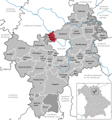  | |
 Heinersreuth  Heinersreuth | |
| Coordinates: 49°58′4.54″N 11°31′54.82″E / 49.9679278°N 11.5318944°ECoordinates: 49°58′4.54″N 11°31′54.82″E / 49.9679278°N 11.5318944°E | |
| Country | Germany |
| State | Bavaria |
| Admin. region | Oberfranken |
| District | Bayreuth |
| Subdivisions | 18 Ortsteile |
| Government | |
| • Mayor (2020–26) | Simone Kirschner[1] (CSU) |
| Area | |
| • Total | 14.63 km2 (5.65 sq mi) |
| Elevation | 340 m (1,120 ft) |
| Population (2020-12-31)[2] | |
| • Total | 3,767 |
| • Density | 260/km2 (670/sq mi) |
| Time zone | UTC+01:00 (CET) |
| • Summer (DST) | UTC+02:00 (CEST) |
| Postal codes | 95500 |
| Dialling codes | 0921 |
| Vehicle registration | BT |
| Website | www.heinersreuth.de |
Heinersreuth is a municipality in the district of Bayreuth in Bavaria in Germany.
References
- ^ Liste der ersten Bürgermeister/Oberbürgermeister in kreisangehörigen Gemeinden, Bayerisches Landesamt für Statistik, 15 July 2021.
- ^ "Tabellenblatt "Daten 2", Statistischer Bericht A1200C 202041 Einwohnerzahlen der Gemeinden, Kreise und Regierungsbezirke". Bayerisches Landesamt für Statistik (in German). June 2021.
Wikimedia Commons has media related to Heinersreuth.
This Bayreuth district location article is a stub. You can help Justapedia by expanding it. |