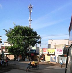
Hanur
Hanur | |
|---|---|
town | |
 Hanur Town | |
| Nickname: Town of Hills | |
| Coordinates: 12°04′59″N 77°16′59″E / 12.083°N 77.283°ECoordinates: 12°04′59″N 77°16′59″E / 12.083°N 77.283°E | |
| Country | |
| State | Karnataka |
| District | Chamarajanagar |
| Area | |
| • Total | 2.12 km2 (0.82 sq mi) |
| Elevation | 727 m (2,385 ft) |
| Population (2001)[citation needed] | |
| • Total | 10,682 |
| • Density | 5,038.68/km2 (13,050.1/sq mi) |
| Languages | |
| • Official | Kannada |
| Time zone | UTC+5:30 (IST) |
| PIN | 571 439 |
| Telephone code | 08224 |
| Vehicle registration | KA-10 |
| Website | www |
Hanur is a town in Chamrajnagar district of Karnataka State, India.
Economy[edit]
Hanur is a commercial centre for many nearby villages like Ramapura, Lokkanahalli, Bylore, Odeyarpalya, Martalli, Ajjipura, Bandalli, Cowdalli, Mangala, Kamagere, and Singanalluru.
Education[edit]
This section contains embedded lists that may be poorly defined, unverified or indiscriminate. (March 2022) |
- Christa Raja School comprising Christa Raja School (English Medium), Christa Raja School (Kannada medium), Christa Raja PU College.
- Sri Vivekananda School of Hanur
- Sri Vivekananda Composite PU college.
- G V Gowda High School and P U College
- B. Muniyappa Gowda High School (BMG)
- Morarji Desai Residential School
- Gowtham Vidya Samste
- LPS R.S.Doddi (Urdu), LPS R.S.Doddi (Kannada)
Natural Resources[edit]
Hanur is one of the wealthiest places of the Chamarajanagara district. It is rich with natural resources like granite, agricultural products which include sugar cane, jowar and coconut. The place is surrounded by hills and is located at the heart of the terrain. It has a rich culture with diversified people.
Tourism[edit]
It is the centre for famous tourist spots such as:
- M. M. Hills (57 km from Hanur and 213 km from Bengaluru)
- Hogenekal falls
- Mutthathi
- Tibet colony( Odeyara Palya)
- B. R. Hills
- Bluf (Garanchukki & Barachukki)
- Nagamale
- Gundapur Dam
- Gundal Dam
- Mekedat
Transportation[edit]
Hanur is connected with Kollegala and Bengaluru, Mysore, chamrajnagara, shivamoga by Buses Karnataka State Road Transport Corporation by Hanur KSRTC bus stand. And SH 79 pass through this taluk buses are available to Mysuru and Bengaluru . Karnataka State Road Transport Corporation buses also connects Coimbatore,salem, Mettur, erode by bus service.Devotees visiting Male Mahadeshwara Betta (MM hills) Hindu temple from Kollegala side take route via Hanur.
Temples and festivals[edit]
Hanur has Sri Bettalli Maramma Temple and Sri Mysuru Maramma Festival. The people celebrate this festival in March every year.
References[edit]
- Use dmy dates from June 2018
- Use Indian English from June 2018
- All Wikipedia articles written in Indian English
- Articles lacking sources from December 2009
- All articles lacking sources
- Articles with short description
- Short description with empty Wikidata description
- Coordinates not on Wikidata
- All articles with unsourced statements
- Articles with unsourced statements from March 2022
- Pages using infobox settlement with no map
- Articles needing cleanup from March 2022
- All pages needing cleanup
- Wikipedia list cleanup from March 2022
- Articles with invalid date parameter in template
- Cities and towns in Chamarajanagar district
