Hưng Yên province
(Redirected from Hưng Yên Province)
Hưng Yên province
Tỉnh Hưng Yên | |
|---|---|
        | |
| Nickname: Idyllic Prosperity | |
 Location of Hưng Yên within Vietnam | |
| Coordinates: 20°50′N 106°5′E / 20.833°N 106.083°ECoordinates: 20°50′N 106°5′E / 20.833°N 106.083°E | |
| Country | |
| Region | Red River Delta |
| Capital | Hưng Yên |
| Subdivision | 1 city, 8 rural districts, one town |
| Government | |
| • Type | Province |
| • Body | Hưng Yên Provincial People's Council |
| • Chairman of People's Council | Trần Quốc Toản |
| • Chairman of People's Committee | Trần Quốc Văn |
| Area | |
| • Province | 930.22 km2 (359.16 sq mi) |
| Population (2021)[2] | |
| • Province | 1,269,090 |
| • Density | 1,400/km2 (3,500/sq mi) |
| • Urban | 209,726 |
| Ethnic groups | |
| • Vietnamese[3] | 99.1% |
| • Tày | 0.2% |
| • Thái | 0.2% |
| • Mường | 0.2% |
| • Others | 0.3% |
| Time zone | UTC+07:00 (ICT) |
| Area codes | 221 |
| ISO 3166 code | VN-66 |
| License plate | 89 |
| Climate | Cwa |
| Website | hungyen.gov.vn |
Hưng Yên (Vietnamese: [hɨŋ˧˧ ʔiən˧˧] (![]() listen)) is a province in the Red River Delta of northern Vietnam. It covers an area of 930.22 km2 (359.2 sq mi), comprising 1 city, 8 rural districts, and 1 district-leveled town, with a population of over 1 million people as of 2019. The province is a settlement along the banks of the Red River, bordered by 5 provinces and municipalities (Bắc Ninh province, Hải Dương province, Hà Nội, Thái Bình province, Hà Nam province).
listen)) is a province in the Red River Delta of northern Vietnam. It covers an area of 930.22 km2 (359.2 sq mi), comprising 1 city, 8 rural districts, and 1 district-leveled town, with a population of over 1 million people as of 2019. The province is a settlement along the banks of the Red River, bordered by 5 provinces and municipalities (Bắc Ninh province, Hải Dương province, Hà Nội, Thái Bình province, Hà Nam province).
Climate
| Climate data for Hưng Yên | |||||||||||||
|---|---|---|---|---|---|---|---|---|---|---|---|---|---|
| Month | Jan | Feb | Mar | Apr | May | Jun | Jul | Aug | Sep | Oct | Nov | Dec | Year |
| Record high °C (°F) | 32.0 (89.6) |
33.6 (92.5) |
37.6 (99.7) |
37.0 (98.6) |
40.5 (104.9) |
39.4 (102.9) |
40.5 (104.9) |
37.8 (100.0) |
36.4 (97.5) |
35.3 (95.5) |
34.5 (94.1) |
31.6 (88.9) |
40.5 (104.9) |
| Average high °C (°F) | 19.5 (67.1) |
19.7 (67.5) |
22.3 (72.1) |
26.7 (80.1) |
30.9 (87.6) |
32.4 (90.3) |
32.7 (90.9) |
31.7 (89.1) |
30.5 (86.9) |
28.3 (82.9) |
25.2 (77.4) |
21.7 (71.1) |
26.8 (80.2) |
| Daily mean °C (°F) | 16.2 (61.2) |
16.9 (62.4) |
19.6 (67.3) |
23.5 (74.3) |
27.0 (80.6) |
28.6 (83.5) |
29.0 (84.2) |
28.4 (83.1) |
27.1 (80.8) |
24.5 (76.1) |
21.1 (70.0) |
17.8 (64.0) |
23.3 (73.9) |
| Average low °C (°F) | 14.0 (57.2) |
15.0 (59.0) |
17.8 (64.0) |
21.4 (70.5) |
24.2 (75.6) |
25.8 (78.4) |
26.3 (79.3) |
25.8 (78.4) |
24.6 (76.3) |
21.8 (71.2) |
18.4 (65.1) |
15.1 (59.2) |
20.8 (69.4) |
| Record low °C (°F) | 4.9 (40.8) |
5.3 (41.5) |
6.6 (43.9) |
12.2 (54.0) |
16.5 (61.7) |
19.4 (66.9) |
20.6 (69.1) |
21.8 (71.2) |
16.5 (61.7) |
12.5 (54.5) |
8.4 (47.1) |
4.8 (40.6) |
4.8 (40.6) |
| Average precipitation mm (inches) | 26 (1.0) |
25 (1.0) |
48 (1.9) |
92 (3.6) |
172 (6.8) |
229 (9.0) |
219 (8.6) |
286 (11.3) |
261 (10.3) |
187 (7.4) |
75 (3.0) |
24 (0.9) |
1,644 (64.7) |
| Average precipitation days | 9.1 | 12.8 | 16.6 | 13.8 | 13.1 | 14.2 | 13.1 | 15.5 | 13.7 | 11.2 | 7.3 | 5.5 | 146.0 |
| Average relative humidity (%) | 85.2 | 87.6 | 90.1 | 89.8 | 86.2 | 84.4 | 84.0 | 87.1 | 86.9 | 84.8 | 82.6 | 82.4 | 85.9 |
| Mean monthly sunshine hours | 75 | 42 | 49 | 93 | 187 | 178 | 205 | 179 | 179 | 173 | 139 | 127 | 1,625 |
| Source: Vietnam Institute for Building Science and Technology[4] | |||||||||||||
Gallery
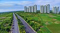 Xuân Quan Urban Area
 Ecopark Văn Giang
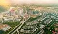 Khu đô thị Văn Giang Urban area
PVF - Văn Giang Vietnam Youth Football Training Center

Hưng Yên City Center

Phố Nối A Industrial Park - Yên Mỹ, Mỹ Hào, Văn Lâm

Thăng Long II Industrial Park - Yên Mỹ

Văn Giang Towm

Hưng Yên City Square

Nôm Pagoda - Văn Lâm


References
- ^ "Phê duyệt và công bố kết quả thống kê diện tích đất đai của cả nước năm 2018" [Announcements of area statistics for the whole country in 2018]. Act No. 2908/QĐ-BTNMT of November 13, 2019 (in Vietnamese). Ministry of Natural Resources and Environment (Vietnam). Archived April 16, 2021, at the Wayback Machine - the data in the report are in hectares, rounded to integers
- ^ a b General Statistics Office of Vietnam (2021). "Completed Results of the 2019 Viet Nam Population and Housing Census" (PDF). Statistical Publishing House (Vietnam). ISBN 978-604-75-1532-5.
- ^ Also called Kinh people
- ^ "Vietnam Building Code Natural Physical & Climatic Data for Construction" (PDF). Vietnam Institute for Building Science and Technology. Archived from the original (PDF) on 22 July 2018. Retrieved 6 August 2018.
Places adjacent to Hưng Yên province | ||||||||||||||||
|---|---|---|---|---|---|---|---|---|---|---|---|---|---|---|---|---|
| ||||||||||||||||