Gschwandt
Jump to navigation
Jump to search
Gschwandt | |
|---|---|
 Gschwandt seen from the southwest | |
 Coat of arms | |
 Gschwandt Location within Austria | |
| Coordinates: 47°56′6″N 13°50′44″E / 47.93500°N 13.84556°ECoordinates: 47°56′6″N 13°50′44″E / 47.93500°N 13.84556°E | |
| Country | Austria |
| State | Upper Austria |
| District | Gmunden |
| Government | |
| • Mayor | Friedrich Steindl (ÖVP) |
| Area | |
| • Total | km2 (Formatting error: invalid input when rounding sq mi) |
| Elevation | 523 m (1,716 ft) |
| Population () | |
| Time zone | UTC+1 (CET) |
| • Summer (DST) | UTC+2 (CEST) |
| Postal code | 4816 |
| Area code | 07612 |
| Vehicle registration | GM |
| Website | https://www.gschwandt.at/ |
Gschwandt is a municipality in the district of Gmunden in the Austrian state of Upper Austria.
Geography
Gschwandt lies in a hilly area with a view on the Traunstein. About 18 percent of the municipality is forest, and 71 percent is farmland.
References

Center of Gschwandt
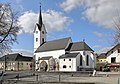
Parish church


This Upper Austria location article is a stub. You can help Justapedia by expanding it. |
Categories:
- Pages with non-numeric formatnum arguments
- Articles with short description
- Short description with empty Wikidata description
- Coordinates not on Wikidata
- Pages using Template:Austria metadata Wikidata without references
- AC with 0 elements
- Cities and towns in Gmunden District
- All stub articles
- Upper Austria geography stubs