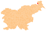
Gornji Črnci
Jump to navigation
Jump to search
Gornji Črnci | |
|---|---|
| Coordinates: 46°44′13.7″N 16°1′19.71″E / 46.737139°N 16.0221417°ECoordinates: 46°44′13.7″N 16°1′19.71″E / 46.737139°N 16.0221417°E | |
| Country | |
| Traditional region | Prekmurje |
| Statistical region | Mura |
| Municipality | Cankova |
| Area | |
| • Total | 1.59 km2 (0.61 sq mi) |
| Elevation | 242.1 m (794.3 ft) |
| Population (2020) | |
| • Total | 135 |
| • Density | 85/km2 (220/sq mi) |
| [1] | |
Gornji Črnci (pronounced [ˈɡoːɾnji ˈtʃəɾntsi]; Hungarian: Királyszék[2]) is a village in the Municipality of Cankova in the Prekmurje region of northeastern Slovenia.
Name
Gornji Črnci was attested in historical sources in 1366 as Korlatfalua, a corruption of Hungarian Konradfalva (i.e., 'Konrad's village'). Today's Slovenian name Gornji Črnci (literally, 'upper Črnci') is derived from Črnec Creek, a tributary of the Ledava River that flows through the village.[3]
References
- ^ Statistical Office of the Republic of Slovenia
- ^ Radkersburg und Luttenberg (map, 1:75,000). 1894. Vienna: K.u.k. Militärgeographisches Institut.
- ^ Zelko, Ivan (1958). "Prekmurska vodna imena v knjigi Franceta Bezlaja Slovenska vodna imena". Slavistična revija. 11 (3–4): 247. Retrieved March 7, 2020.
External links

