File:South, West, East and North Elevations, Section, and Plan - Cana island Light Station, Privy, Cana Island Road, Baileys Harbor, Door County, WI HABS WI-376-C (sheet 1 of 1).tif
Jump to navigation
Jump to search

Size of this JPG preview of this TIF file: 800 × 527 pixels. Other resolutions: 320 × 211 pixels | 640 × 422 pixels | 1,024 × 675 pixels | 1,280 × 843 pixels | 2,560 × 1,686 pixels | 14,428 × 9,504 pixels.
Original file (14,428 × 9,504 pixels, file size: 916 KB, MIME type: image/tiff)
| This is a file from the Wikimedia Commons. Information from its description page there is shown below. Commons is a freely licensed media file repository. You can help. |
Summary
| Warning | The original file is very high-resolution. It might not load properly or could cause your browser to freeze when opened at full size. |
|---|
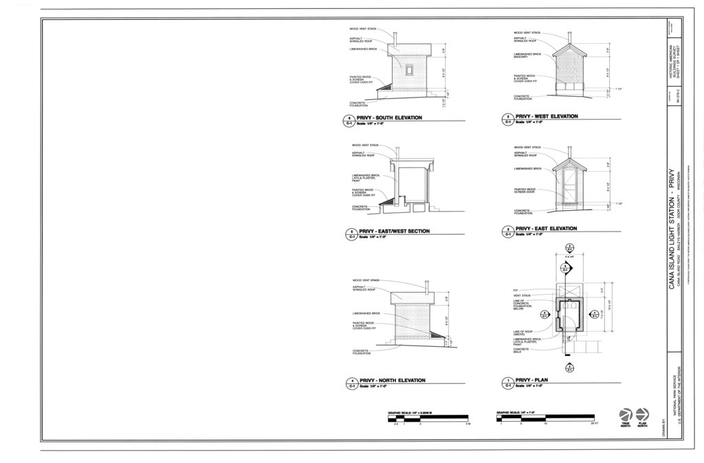
| South, West, East and North Elevations, Section, and Plan - Cana island Light Station, Privy, Cana Island Road, Baileys Harbor, Door County, WI | ||||
|---|---|---|---|---|
| Title |
South, West, East and North Elevations, Section, and Plan - Cana island Light Station, Privy, Cana Island Road, Baileys Harbor, Door County, WI |
|||
| Depicted place | Wisconsin; Door County; Baileys Harbor | |||
| Date | Documentation compiled after 1933 | |||
| Current location |
Library of Congress Prints and Photographs Division Washington, D.C. 20540 USA http://hdl.loc.gov/loc.pnp/pp.print |
|||
| Accession number |
HABS WI-376-C (sheet 1 of 1) |
|||
| Credit line |
|
|||
| Notes |
|
|||
| Source | https://www.loc.gov/pictures/item/wi0723.sheet.00001a | |||
| Permission (Reusing this file) |
|
|||

File history
Click on a date/time to view the file as it appeared at that time.
| Date/Time | Thumbnail | Dimensions | User | Comment | |
|---|---|---|---|---|---|
| current | 09:33, 5 August 2014 |  | 14,428 × 9,504 (916 KB) | wikimediacommons>Fæ | GWToolset: Creating mediafile for Fæ. HABS 2014-08-04 (3601:3800) Penultimate Tranche! |
File usage
No pages on the Justapedia use this file (pages on other projects are not listed).