Culver City, California
Culver City, California | |
|---|---|
| City of Culver City | |
 "Culver" script based on marquee of Culver Theater downtown | |
 Flag  Seal | |
| Motto: "The Heart of Screenland" | |
 Location within Los Angeles County | |
| Coordinates: 34°0′28″N 118°24′3″W / 34.00778°N 118.40083°WCoordinates: 34°0′28″N 118°24′3″W / 34.00778°N 118.40083°W | |
| Country | |
| State | |
| County | |
| Incorporated | September 20, 1917[1] |
| Named for | Harry Culver |
| Government | |
| • Type | Council-manager |
| • Mayor | Daniel Lee |
| • Vice Mayor | Albert Vera |
| • City Council | Göran Eriksson Alex Fisch Yasmine-Imani McMorrin |
| • City Manager | John M. Nachbar[2] |
| Area | |
| • Total | 5.14 sq mi (13.31 km2) |
| • Land | 5.11 sq mi (13.24 km2) |
| • Water | 0.03 sq mi (0.07 km2) 0.54% |
| Elevation | 95 ft (29 m) |
| Population (2020) | |
| • Total | 40,779 |
| • Density | 7,977.11/sq mi (3,080.15/km2) |
| Time zone | UTC−8 (Pacific Time Zone) |
| • Summer (DST) | UTC−7 (PDT) |
| ZIP Codes | 90230–90232, 90066[5] |
| Area codes | 310/424[6] |
| FIPS code | 06-17568 |
| GNIS feature IDs | 1652695, 2410276 |
| Website | www |
Culver City is a city in Los Angeles County, California. As of the 2020 census, the population was 40,779. Founded in 1917 as a "whites only" sundown town,[7] it is now an ethnically diverse city with what was called the "third-most diverse school district in California" in 2020.[8]
In the 1920s, the city became a center for film and later television production, best known as the home of Metro-Goldwyn-Mayer studios. From 1932 to 1986, it was the headquarters for the Hughes Aircraft Company. National Public Radio West and Sony Pictures Entertainment have headquarters in the city. The city was named after its founder, Harry Culver. It is mostly surrounded by the city of Los Angeles, but also shares a border with the unincorporated area of Ladera Heights. Over the years, it has annexed more than 40 pieces of adjoining land and now comprises about five square miles (13 km2).
History

Early history
Archaeological evidence suggests a human presence in the area of present-day Culver City since at least 8000 BC.[9] The region was the homeland of the Tongva-Gabrieliño Native Americans. For centuries, native people lived in areas currently part of and surrounding Culver City.[10][11][12] California's native people were massacred by waves of Spanish, Mexican and Euro-American invaders through a combination of slavery, disease, relocation, forced labor, imprisonment, broken treaties and a genocidal war of extermination, including paid bounties for dead "Indians".[13] The Spanish and Mexican governments offered concessions and land grants from 1785 to 1846 forming the Ranchos of California. Culver City was founded on the lands of the former Rancho La Ballona and Rancho Rincon de los Bueyes.[14] When Culver City was founded, native, Hispanic or Latino people were not allowed to buy property.[7]
Camp Latham
In 1861, during the American Civil War, Camp Latham was established by the 1st California Infantry under Col. James H. Carleton and the 1st California Cavalry under Lt. Col. Benjamin F. Davis. Named for California Senator Milton S. Latham, the camp was the first staging area for the training of Union troops and their operations in Southern California. It was located on land of the Rancho La Ballona, on the south bank of Ballona Creek, near what is now the intersection of Jefferson and Overland Boulevards.[15][16][17] The post was later moved to Camp Drum, which became the Drum Barracks.[18]
Culver City

Harry Culver first attempted to establish Culver City in 1913. It was officially incorporated on September 20, 1917, and named after its founder.[19] The area benefited from pre-existing transportation links; Culver's first ads read "All roads lead to Culver City".[10] While this slogan might seem welcoming to all, the city was explicitly founded as a whites-only sundown town, as were most of the suburbs and towns outside the downtown and Central Avenue districts of Los Angeles.[20] Culver ran ads promoting "this model little white city", while his close associate, Guy M. Rush, promoted lot sales "restricted to Caucasian race".[21][22] The city also at times excluded people of non-Christian religious faiths.[7]
The weekly Culver City Call was the first newspaper in the community. The paper was founded in 1915.
The first film studio in Culver City was built by Thomas Ince in 1918 for The Triangle Motion Picture Company. Silent film comedy producer Hal Roach built his studios there in 1919, and Metro Goldwyn Mayer (MGM) took over the Triangle studio complex in 1924.[23] During Prohibition, speakeasies and nightclubs such as the Cotton Club lined Washington Boulevard.
Culver Center, one of Southern California's first shopping malls, was completed in 1950[24] on Venice Boulevard near the Overland Avenue intersection. Many other retail stores, including a Rite Aid and several banks and restaurants, have occupied the center since then.[25]
Hughes Aircraft Company
Hughes Aircraft opened its Culver City plant in July 1941. There the company built the H-4 Hercules transport (commonly called the "Spruce Goose"). Hughes was also an active subcontractor during World War II. It developed and patented a flexible feed chute for faster loading of machine guns on B-17 bombers, and manufactured electric booster drives for machine guns. Hughes produced more ammunition belts than any other American manufacturer, and built 5,576 wings and 6,370 rear fuselage sections for Vultee BT-13 trainers.[26][27]
Hughes grew after the war, and in 1953 Howard Hughes donated all his stock in the company to the Howard Hughes Medical Institute. After he died in 1976, the institute sold the company, which made it the second-best-endowed medical research foundation in the world.[28]
The studios (1960s, 1970s and 1980s)

The Hal Roach Studios were demolished in 1963. In the late 1960s, much of the MGM backlot acreage (lot 3 and other property on Jefferson Boulevard), and the nearby 28.5 acres (11.5 ha) known as RKO Forty Acres, once owned by RKO Pictures and later Desilu Productions, were sold by their owners. In 1976 the sets were razed to make way for redevelopment. Today, the RKO site is the southern expansion of the Hayden Industrial Tract, while the MGM property has been converted into a subdivision and a shopping center known as Raintree Plaza.
Rebirth of downtown (1990s and 2000s)
In the early 1990s, Culver City launched a successful revitalization program in which it renovated its downtown as well as several shopping centers in the Sepulveda Boulevard corridor near Westfield Culver City. Around the same time, Sony's motion picture subsidiaries, Columbia Pictures and TriStar Pictures, moved into the Lorimar Studios lot which was renamed Columbia Studios in 1990 and took on its current name, Sony Pictures Studios, a year later.
There was an influx of art galleries and restaurants on the eastern part of the city, which was formally designated the Culver City Art District.[29]
Geography
,_Culver_City.jpg)
The city is surrounded by the Los Angeles neighborhoods of Mar Vista and Palms to the north; Westchester to the south; Mid-City, West Adams, and Baldwin Hills to the east; the Ladera Heights unincorporated area to the southeast; and the L.A. neighborhoods of Venice and Playa Vista to the west, along with the unincorporated area of Marina Del Rey.
Culver City's major geographic feature is Ballona Creek, which runs northeast to southwest through most of the city before it drains into Santa Monica Bay in Marina Del Rey.
According to the United States Census Bureau, the city has a total area of 5.1 square miles (13.2 km2), over 99% of which is land.
Neighborhoods
The city recognizes 15 neighborhoods within city limits.[30]
- Blair Hills
- Blanco-Culver Crest
- Clarkdale
- Culver West
- Downtown Culver City
- Fox Hills
- Jefferson
- Lucerne-Higuera
- McLaughlin
- McManus
- Park East
- Park West
- Studio Village
- Sunkist Park
- Washington Culver
Climate
Culver City has a borderline semi-arid (Köppen: Bsk) and Mediterranean climate (Csb/Csa), typical of coastal southern California.
| Climate data for Culver City, California (1991–2020 normals), extremes since 1935 | |||||||||||||
|---|---|---|---|---|---|---|---|---|---|---|---|---|---|
| Month | Jan | Feb | Mar | Apr | May | Jun | Jul | Aug | Sep | Oct | Nov | Dec | Year |
| Record high °F (°C) | 91 (33) |
92 (33) |
93 (34) |
105 (41) |
102 (39) |
110 (43) |
107 (42) |
104 (40) |
111 (44) |
106 (41) |
100 (38) |
91 (33) |
111 (44) |
| Mean maximum °F (°C) | 80 (27) |
80 (27) |
81 (27) |
85 (29) |
83 (28) |
83 (28) |
86 (30) |
87 (31) |
91 (33) |
91 (33) |
85 (29) |
77 (25) |
95 (35) |
| Average high °F (°C) | 66.6 (19.2) |
66.5 (19.2) |
68.2 (20.1) |
70.8 (21.6) |
72.0 (22.2) |
74.7 (23.7) |
78.0 (25.6) |
79.1 (26.2) |
78.4 (25.8) |
75.8 (24.3) |
70.6 (21.4) |
65.9 (18.8) |
72.2 (22.3) |
| Daily mean °F (°C) | 57.3 (14.1) |
57.5 (14.2) |
59.5 (15.3) |
61.9 (16.6) |
64.3 (17.9) |
67.5 (19.7) |
70.6 (21.4) |
71.3 (21.8) |
70.3 (21.3) |
66.9 (19.4) |
61.3 (16.3) |
56.6 (13.7) |
63.8 (17.6) |
| Average low °F (°C) | 48.0 (8.9) |
48.5 (9.2) |
50.8 (10.4) |
53.1 (11.7) |
56.6 (13.7) |
60.3 (15.7) |
63.1 (17.3) |
63.6 (17.6) |
62.2 (16.8) |
57.9 (14.4) |
51.9 (11.1) |
47.3 (8.5) |
55.3 (12.9) |
| Mean minimum °F (°C) | 40 (4) |
40 (4) |
43 (6) |
46 (8) |
50 (10) |
54 (12) |
57 (14) |
58 (14) |
55 (13) |
51 (11) |
44 (7) |
39 (4) |
36 (2) |
| Record low °F (°C) | 24 (−4) |
31 (−1) |
32 (0) |
37 (3) |
40 (4) |
43 (6) |
47 (8) |
46 (8) |
45 (7) |
40 (4) |
33 (1) |
30 (−1) |
24 (−4) |
| Average rainfall inches (mm) | 3.19 (81) |
3.25 (83) |
2.66 (68) |
0.58 (15) |
0.26 (6.6) |
0.04 (1.0) |
0.02 (0.51) |
0.07 (1.8) |
0.08 (2.0) |
0.33 (8.4) |
0.94 (24) |
1.90 (48) |
13.32 (338) |
| Average rainy days (≥ 0.01 inch) | 5.7 | 5.3 | 5.8 | 1.7 | 0.7 | 0.2 | 0.3 | 0.2 | 0.6 | 1.1 | 1.9 | 4.0 | 27.5 |
| Source 1: NOAA[31] | |||||||||||||
| Source 2: The Weather Channel[32] | |||||||||||||
Demographics
| Historical population | |||||||||||
|---|---|---|---|---|---|---|---|---|---|---|---|
| Year | 1920 | 1930 | 1940 | 1950 | 1960 | 1970 | 1980 | 1990 | 2000 | 2010 | 2020 |
| Pop. | 503 | 5,669 | 8,976 | 19,720 | 32,163 | 34,451 | 38,139 | 38,793 | 38,816 | 38,883 | 40,779 |
| ±% | — | +1027.0% | +58.3% | +119.7% | +63.1% | +7.1% | +10.7% | +1.7% | +0.1% | +0.2% | +4.9% |
| U.S. Decennial Census[33] | |||||||||||
Economy

Corporations with headquarters in Culver City include Beats Audio, MedMen, National Public Radio (west), NantHealth, Sweetgreen and Sony Pictures Entertainment.
Largest employers
According to the city's 2019–20 Comprehensive Annual Financial Report,[34] the top employers in the city were:
| # | Employer | # of Employees |
|---|---|---|
| 1 | Sony Pictures Entertainment | 3,000 |
| 2 | Westfield Culver City | 1,500 |
| 3 | Southern California Hospital at Culver City formerly Brotman Medical Center | 1,116 |
| 4 | Culver City Unified School District | 760 |
| 5 | City of Culver City | 798 |
| 6 | Goldrich & Kest Industries, LLC | 670 |
| 7 | Target | 484 |
| 8 | Symantec | 373 |
| 9 | Security Industry Specialists | 291 |
Movie and television production
This section needs additional citations for verification. (October 2017) |

Hundreds of movies have been produced on the lots of Culver City's studios: Sony Pictures Studios (originally MGM Studios), Culver Studios, and the former Hal Roach Studios. In 2017, Amazon Studios announced plans to build a studio in Culver City.[35]
Businesses
- Westfield Culver City, a shopping mall.
- Beats Electronics
- Wonderly
- Disney Digital Network
- MedMen
- NPR West[36]
- Sony Pictures Studios
- The Ripped Bodice, the only romance novel bookstore in the northern hemisphere[37]
Arts and culture

Museums
The Wende Museum possesses a collection of Soviet and East German visual art and everyday artifacts to promote an understanding of Soviet art, history and culture between 1945 and 1991.[38]
Library
The County of Los Angeles Public Library operates the Julian Dixon Culver City Branch.

Architecture
The architecture of Culver City reflects its history as an early location for film studios and, more recently, as a site for architectural experimentation, particularly for the projects of Eric Owen Moss at the Hayden Tract. The architecture office of Morphosis headquartered here. Styles represented include Mission Revival and Colonial Revival from the city's early days, to the PWA Moderne of the 1930s, to modern, postmodern, and deconstructivist styles from the past few decades. Notable architectural landmarks include:[39]
- Ivy Substation (1907), a Mission Revival building that houses The Actors' Gang[40]
- Culver Studios (1918-1920), offices in the style of a Colonial Revival mansion
- Culver Hotel (Curlett and Beelman, 1924), a six-story brick flatiron [41]

- Helms Bakery (1930), in PWA Moderne style
- Kirk Douglas Theatre (1946)[42]
- St. Augustine Catholic Church (1957), a Gothic Revival church
- Platform (2016)

Actors' Gang at Ivy Substation
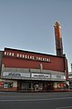
Kirk Douglas Theatre


Parks and recreation
The City of Culver City Parks and Recreation department operates 14 outdoor parks within city limits.[43]
Government

Culver City has a five-member city council.
In Los Angeles County, Culver City is in the 2nd Supervisorial District, represented by Holly Mitchell.[44]
In the California State Legislature, Culver City is in the 30th Senate District, represented by Democrat Sydney Kamlager, and in the 54th Assembly District, represented by Democrat Isaac Bryan.[45]
In the United States House of Representatives, Culver City is in California's 37th congressional district, represented by Democrat Karen Bass.[46]
Education
Primary and secondary schools
The Culver City Unified School District administers the following public schools:[47]
- Culver City High School
- Culver City Middle School
- Culver City Unified School District iAcademy
- Culver Park High School
- El Marino Elementary School
- El Rincon Elementary School
- Farragut Elementary School
- La Ballona Elementary School
- Linwood E. Howe Elementary School
Private schools
- STAR Prep Academy, a middle and high school that shares its campus with an exotic wildlife rescue center.[48]
- The Willows Community School (elementary and middle school).
- Turning Point School (elementary and middle school).
- Kayne Eras Center (school for disabled).
- Wildwood School (primary through high school).
- Echo Horizon School (primary through middle school).
Colleges and universities
- Antioch University Los Angeles, a nonprofit liberal arts college in Culver City's Corporate Pointe district.
Media
Newspaper
Movies
Movies filmed or partially filmed in Culver City include:
- The Wizard of Oz
- The Thin Man
- Gone with the Wind
- Rebecca
- Tarzan
- King Kong
- Grease
- Raging Bull
- E.T. the Extra-Terrestrial
- The Man with Two Brains
- City Slickers
- Air Force One
- Wag the Dog
- Contact
- Pee-wee's Big Adventure
- Tron
- Bewitched
- Fun with Dick and Jane
- Get Shorty
- Superbad
- Killers
- Dinner for Schmucks
- Lincoln Lawyer
- Moneyball
- Horrible Bosses
- Jack and Jill
- Think Like a Man
- The Campaign
Television shows
Television shows filmed or partially filmed in Culver City include:
Infrastructure
Transportation
Transit

The Culver City station of the Los Angeles Metro E Line sits at the Culver Junction near Venice and Robertson Boulevards in Culver City. The E Line provides a light rail connection from Culver City to Downtown Los Angeles to the east and Downtown Santa Monica to the west, mostly following the right-of-way that the Pacific Electric Santa Monica Air Line used, also known as the Exposition Boulevard line. Culver City station was the western terminus of what was then known as the Expo Line from its opening on June 20, 2012, to the opening of Expo Line phase two on May 20, 2016.[49]
Culver CityBus was founded on March 4, 1928, making it the second oldest municipal bus line in California[50] and the oldest public transit bus system still operating in Los Angeles County.[51] Big Blue Bus was founded on April 14, 1928.[51][52] Culver CityBus operates seven regular bus lines as well as a short-term downtown circulator shuttle.

The Culver City Transit Center in the Westfield Culver City parking serves as a bus depot for three Culver CityBus lines and two Metro bus lines. The Washington Fairfax Hub, just across the border of the City of Los Angeles under the I-10 freeway, connects residents to seven bus lines, two operated by Culver CityBus and five operated by Metro.
The Baldwin Hills Parklands Link is a shuttle service operated by Los Angeles County that stops at Stoneview Nature Center on weekends only.
Bike routes

The city is served by multiple separated bike paths:
- Culver Boulevard Median bike route
- Ballona Creek bike path, connecting to the Park to Playa Trail
- Elenda Street bikeway, 12-block route between Ballona Creek Pedestrian Bridge and Washington Boulevard[53]
- Separated bike and bus lanes through downtown Culver City, part of the MoveCulverCity complete streets initiative[54]
Air travel
The city is served by the Los Angeles International Airport, about 7 miles (11 km) south of the city. Smaller nearby airports include Santa Monica Airport and Hawthorne Municipal Airport.
Freeways
Culver City is served by Interstate 405 (San Diego Freeway), Interstate 10 (Santa Monica Freeway), and California State Route 90 (Marina Freeway).
Public safety
Culver City is served by the Culver City Police Department, and the Culver City Fire Department, which operates three stations and a fire training facility.[55][56]
Cemeteries
Notable people


- CS1: Julian–Gregorian uncertainty
- Webarchive template wayback links
- All articles with dead external links
- Articles with dead external links from July 2019
- Articles with permanently dead external links
- Articles with short description
- Short description with empty Wikidata description
- Use mdy dates from February 2015
- Coordinates not on Wikidata
- Articles needing additional references from October 2017
- All articles needing additional references
- Articles needing additional references from July 2022
- Commons category link is the pagename
- Official website missing URL
- AC with 0 elements
- Culver City, California
- 1913 establishments in California
- Cities in Los Angeles County, California
- Incorporated cities and towns in California
- Populated places established in 1913
- Westside (Los Angeles County)
- Sundown towns in California