Clachaig
Jump to navigation
Jump to search
Clachaig
| |
|---|---|
 Clachaig Village | |
 Clachaig Location within Argyll and Bute | |
| OS grid reference | NS 12100 81400 |
| Council area |
|
| Lieutenancy area |
|
| Country | Scotland |
| Sovereign state | United Kingdom |
| Post town | DUNOON, ARGYLL |
| Postcode district | PA23 |
| Dialling code | 01369 |
| UK Parliament |
|
| Scottish Parliament |
|
Clachaig; (Scottish Gaelic: Clachaig) is a small settlement, on the Cowal peninsula in Argyll and Bute, Scotland.[1][2] It is located on the B836 road between the Holy Loch and Loch Striven, the hamlet is just over a mile long.[3] Clachaig is a Gaelic word meaning 'stone place'.[4]
The Hamlet consists of twenty-two houses and was built for accommodation for the workers of the powder mill. The mill manufactured gunpowder.[5]
The river at the bottom of the glen is the Blackcraig Burn that joins the Little Eachaig River, then joining the River Eachaig and flowing into the Holy Loch.
Gallery
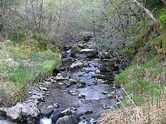
Blackcraig Burn, Clachaig.

References
- ^ Ordnance Survey: Landranger map sheet 63 Firth of Clyde (Greenock & Rothesay) (Map). Ordnance Survey. 2014. ISBN 9780319229699.
- ^ "Ordnance Survey: 1:50,000 Scale Gazetteer" (csv (download)). www.ordnancesurvey.co.uk. Ordnance Survey. 1 January 2016. Retrieved 18 February 2016.
- ^ "B836 - Roader's Digest: The SABRE Wiki". Sabre-roads.org.uk. 18 November 2016. Retrieved 15 December 2016.
- ^ Gaelic place names of Scotland
- ^ "Clachaig, Glenlean Blackpowder Works". ScotlandsPlaces. Retrieved 14 December 2016.
External links
- Map sources for Clachaig
Wikimedia Commons has media related to Clachaig.
This Argyll and Bute location article is a stub. You can help Justapedia by expanding it. |
Categories:
- EngvarB from January 2017
- Use dmy dates from January 2017
- Articles with short description
- Short description with empty Wikidata description
- Articles containing Scottish Gaelic-language text
- Articles with OS grid coordinates
- Coordinates not on Wikidata
- Commons category link is defined as the pagename
- AC with 0 elements
- Villages in Cowal
- Highlands and Islands of Scotland
- All stub articles
- Argyll and Bute geography stubs