Châtillon-sur-Chalaronne
Jump to navigation
Jump to search
This article may be expanded with text translated from the corresponding article in French. (December 2008) Click [show] for important translation instructions.
|
Châtillon-sur-Chalaronne | |
|---|---|
Commune | |
 Town hall | |
.svg) Coat of arms | |
 Châtillon-sur-Chalaronne  Châtillon-sur-Chalaronne | |
| Coordinates: 46°07′00″N 4°58′00″E / 46.1167°N 4.9667°ECoordinates: 46°07′00″N 4°58′00″E / 46.1167°N 4.9667°E | |
| Country | France |
| Region | Auvergne-Rhône-Alpes |
| Department | Ain |
| Arrondissement | Bourg-en-Bresse |
| Canton | Châtillon-sur-Chalaronne |
| Intercommunality | Dombes |
| Government | |
| • Mayor (2020–2026) | Patrick Mathias |
| Area 1 | 17.86 km2 (6.90 sq mi) |
| Time zone | UTC+01:00 (CET) |
| • Summer (DST) | UTC+02:00 (CEST) |
| INSEE/Postal code | 01093 /01400 |
| Elevation | 215–274 m (705–899 ft) (avg. 225 m or 738 ft) |
| 1 French Land Register data, which excludes lakes, ponds, glaciers > 1 km2 (0.386 sq mi or 247 acres) and river estuaries. | |
Châtillon-sur-Chalaronne (French pronunciation: [ʃatijɔ̃ syʁ ʃalaʁɔn], literally Châtillon on Chalaronne) is a commune in the Ain department in eastern France.
History

The town takes its name from a castle built around 1000 AD. It was formerly named Châtillon-les-Dombes.
Geography
The Chalaronne flows northwest through the commune and crosses the town.
Population
| Year | Pop. | ±% p.a. |
|---|---|---|
| 1968 | 2,678 | — |
| 1975 | 3,241 | +2.76% |
| 1982 | 3,518 | +1.18% |
| 1990 | 3,786 | +0.92% |
| 1999 | 4,137 | +0.99% |
| 2007 | 4,904 | +2.15% |
| 2012 | 4,957 | +0.22% |
| 2017 | 4,859 | −0.40% |
| Source: INSEE[1] | ||
Twin towns
- Wächtersbach (Germany)
- Colceag (Romania)
Personalities
- Saint Vincent de Paul: was curate of Châtillon and founded the Brotherhood of Charity (1617)
- Philibert Commerson: botanist, born in Châtillon in 1727
 Church
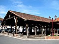 Historic market hall
 Monument Vincent de Paul


See also
References
External links
Wikimedia Commons has media related to Châtillon-sur-Chalaronne.
- Châtillon-sur-Chalaronne official website
- La Dombes and Châtillon-sur-Chalaronne
- Images by Paul C. Maurice
This Ain geographical article is a stub. You can help Justapedia by expanding it. |
Categories:
- Articles with short description
- Short description with empty Wikidata description
- Geography articles needing translation from French Wikipedia
- Coordinates not on Wikidata
- France articles requiring maintenance
- Commons category link is defined as the pagename
- AC with 0 elements
- Communes of Ain
- Dombes
- Ain communes articles needing translation from French Wikipedia
- All stub articles
- Ain geography stubs