Carretera Central (Cuba)
| Carretera Central (CC) | |
|---|---|
| Central Road | |
.png) | |
| Route information | |
| Length | 1,435 km (892 mi) |
| Existed | 1927–present |
| Major junctions | |
| West end | La Fé (Pinar del Río Province) |
| East end | Baracoa (Guantánamo Province) |
| Location | |
| Country | Cuba |
| Major cities | La Fé, Sandino, Pinar del Río, Artemisa, Havana, San José de las Lajas, Matanzas, Colón, Santa Clara, Placetas, Sancti Spíritus, Ciego de Ávila, Florida, Camagüey, Las Tunas, Holguín, Bayamo, Palma Soriano, Santiago de Cuba, Guantánamo, Baracoa |
| Highway system | |
The Carretera Central (CC), meaning "Central Road", is a west-east highway spanning the length of the island of Cuba.
History
Formal construction began in 1927 during the Gerardo Machado administration.[1] It runs along the island of Cuba from west to east, between Pinar del Río and Oriente. It is a two-way single road. It represented an extraordinary economic value during Machado and Fulgencio Batista's administrations. It facilitated faster transportation and effective inter-province commuting.
Route
Description
The Carretera Central starts in the village of La Fe, a hamlet of Sandino, in the western province of Pinar del Río, and links all major cities and province capitals except Cienfuegos.[2] It runs about 1,250 km (777 mi)[3] to Baracoa in the eastern Guantánamo province.
Table
The table below shows the route of the Carretera Central.[2] Note: Provincial seats are shown in bold; the names shown under brackets in the section "Municipality" indicate the municipal seats.
Gallery

Carretera Central near Santo Domingo, Villa Clara province

Through Santo Domingo, Villa Clara province

Through Santa Clara
Through Santa Clara
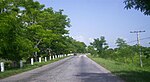
Carretera Central in Villa Clara province

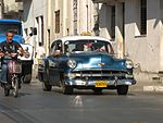
Traffic jam on Carretera

Political poster on Carretera


.jpg)

See also
References
- ^ History of Cuba - Carretera central article
- ^ a b Source: Mapa de Carreteras de Cuba (Road map of Cuba). Ediciones GEO, Havana 2011 - ISBN 959-7049-21-X
- ^ Map and mile by mile description
External links
- (in Spanish) Carretera Central photos
- (in Spanish) Carretera Central on EcuRed
Coordinates: 22°02′32″N 84°16′18″W / 22.04222°N 84.27167°W
- Articles with short description
- Short description with empty Wikidata description
- Articles containing explicitly cited English-language text
- Infobox road maps tracking category
- Infobox road maps for Wikidata migration
- Infobox road articles without wikidata country
- Infobox road articles without wikidata instance of
- Infobox road instances in Cuba
- Commons category link is defined as the pagename
- Articles with Spanish-language sources (es)
- Coordinates not on Wikidata
- Roads in Cuba
- Pinar del Río Province
- Artemisa Province
- Transport in Havana
- Mayabeque Province
- Matanzas Province
- Villa Clara Province
- Sancti Spíritus Province
- Ciego de Ávila Province
- Camagüey Province
- Las Tunas Province
- Holguín Province
- Granma Province
- Santiago de Cuba Province
- Guantánamo Province