Boluran
Boluran
بلوران | |
|---|---|
village | |
 Boluran | |
| Coordinates: 33°33′25″N 47°18′00″E / 33.55694°N 47.30000°ECoordinates: 33°33′25″N 47°18′00″E / 33.55694°N 47.30000°E | |
| Country | |
| Province | Lorestan |
| County | Kuhdasht |
| Bakhsh | Darb-e Gonbad |
| Rural District | Boluran |
| Elevation | 1,505 m (4,938 ft) |
| Population (2016) | |
| • Total | 742[1] |
| Time zone | UTC+3:30 (IRST) |
| • Summer (DST) | UTC+4:30 (IRDT) |
| Area code | (+98) 066 |
Boluran (Persian: بلوران, also Romanized as Bolūrān)[2] is a village in Boluran Rural District, Iran.
This village is located 35 km west of Kuhdasht.[3]
Demographics
As of the 2016 census, its population was 742 (379 men and 363 women), in 217 families.[1] It is the largest village in Boluran Rural District by population. Its residents speak Laki and the predominant religion is Yarsanism.[4]
Gallery
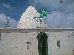
The Shrine of Agha Mirza Hossein (the summit of Boluran mountain).

Boluran Village from the summit of Boluran mountain.
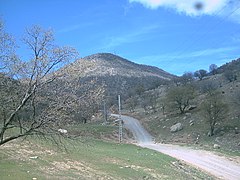
Boluran mountain.

The Historical cemetery on the mountainside of Boluran.

Boluran mountain and village in one image.


Boluran Forest Park

Boluran Forest Park is a park in Kuhdasht.[citation needed] The park suffered extensive forest fire damage. In 2016, a large fire raged for days, damaging hundreds of acres of land.[citation needed]
References
- ^ a b "Statistical Center of Iran > Home". www.amar.org.ir.
- ^ Boluran can be found at GEOnet Names Server, at this link, by opening the Advanced Search box, entering "-3056601" in the "Unique Feature Id" form, and clicking on "Search Database".
- ^ "Google Maps". Google Maps. Retrieved 2020-01-03.
- ^ محمدیان فخرالدین; کاخکی احمد; نورو ززاده چگینی ناصر (2016). "فرایند و چگونگی شکل گیری معماری آیینی یارسان" (PDF). انتشارات پژوهشگاه میراث فرهنگی و گردشگری. 37 (72): 93–108. Retrieved 5 April 2020.
This Kuhdasht County location article is a stub. You can help Justapedia by expanding it. |
- Articles with short description
- Short description with empty Wikidata description
- Coordinates not on Wikidata
- Articles containing Persian-language text
- All articles with unsourced statements
- Articles with unsourced statements from December 2019
- Kurdish settlements in Iran
- Towns and villages in Kuhdasht County
- All stub articles
- Kuhdasht County geography stubs