Boat Rock
Native name: Te Nihokiore, Timata | |
|---|---|
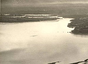
 Boat Rock in the Upper Waitematā Harbour, pictured in 1946 | |
| Geography | |
| Location | Auckland |
| Coordinates | 36°49′47″S 174°41′36″E / 36.829855°S 174.693281°ECoordinates: 36°49′47″S 174°41′36″E / 36.829855°S 174.693281°E |
| Adjacent to | Waitemata Harbour |
| Administration | |
New Zealand | |
Boat Rock is a tiny sandstone island in the Waitematā Harbour of Auckland, New Zealand. Boat Rock is a vanishing island, which is submerged at high tide.
Geology
The rock is a piece of Waitemata Group sandstone exposed in the Waitematā Harbour.[1] The rock is an intertidal reef, exposed during low tide.[2] The surface of Boat Rock is covered in sand and shell deposits.[2]
Boat Rock is home to a number of species including sea slugs such as Dendrodoris citrina, Dendrodoris nigra and Pleurobranchaea maculata, sea snails such as Maoricolpus roseus and Dicathais orbita.[2] In addition, the island is home to kina and a species of chiton, Cryptoconchus porosus.[2]
History
The island was traditionally referred to by Tāmaki Māori iwi by various names, including Te Nihokiore ("The Rat's Tooth"), Timata, Te-Toka-tu-Moana ("The Rock Standing in Mid-Sea"), Te-Waka-o-Tawaroa and Te Mata-o-Kahu.[3][4] Te Nihokiore is likely a metaphor for how the rocks remain sharp despite being battered by the sea, similar to a rat's tooth.[4] The island is the namesake of the Waitematā Harbour, which literally means "Waters of Te Mata".[5] The name refers to Te Arawa chief Kahumatamomoe, who when visiting the harbour placed a mauri stone (a stone of religious significance) on Boat Rock.[5] The name Waitematā originally only referred to the upper harbour area near Boat Rock.[6] Boat Rock was traditionally used as a rohe marker, designating the boundary of influence between different Tāmaki Māori iwi.[7]
In 1873, the island an iron ship beacon was erected on the island,[8] which was damaged by ships in 1905.[9]
References
- ^ Hicks, SR; Kibblewhite, AC (1976). "Seismic reflection profiling in very Shallow waters in the upper Waitemata Harbour, New Zealand". New Zealand Journal of Geology and Geophysics. 19 (2): 213–231. doi:10.1080/00288306.1976.10423518. ISSN 0028-8306.
- ^ a b c d Hayward, Bruce W; Morley, Margaret S; Stephenson, A Brett; Blom, Wilma M; Grenfell, Hugh R; Prasad, Ramola; Rogan, Doug; Thompson, Fiona; Cheetham, Julianne; Webb, Maggie (1999). "Intertidal and subtidal biota and habitats of the central Waitemata Harbour". Auckland Regional Council Technical Publication. 127: 40.
- ^ "Boat Rock". New Zealand Gazetteer. Land Information New Zealand. Retrieved 17 May 2022.
- ^ a b ""Waitemata." Meaning and History. A Popular Error". Auckland Star. Vol. LXII, no. 282. 28 November 1931. p. 12. Retrieved 17 May 2022 – via Papers Past.
- ^ a b Wilson, Karen (28 August 2018). "Brief of Evidence of Karen Akamira Wilson on Behalf of Te Ākitai Waiohua" (PDF). Ministry of Justice. Retrieved 17 May 2022.
- ^ Graham, George (1951). "Tainui". The Journal of the Polynesian Society. 60 (1): 80–92. ISSN 0032-4000.
- ^ Graham, George (1979). "George Graham's Maori Place Names of Auckland". Records of the Auckland Institute and Museum. 16: 11-39.
- ^ "Notice to Mariners". Wellington Independent. Vol. XXVIII, no. 3820. 2 June 1873. p. 2. Retrieved 17 May 2022 – via Papers Past.
- ^ "Untitled". The New Zealand Herald. Vol. XLII, no. 12920. 17 July 1905. p. 6. Retrieved 17 May 2022 – via Papers Past.
- CS1: Julian–Gregorian uncertainty
- Use dmy dates from May 2022
- Use New Zealand English from May 2022
- All Wikipedia articles written in New Zealand English
- Coordinates not on Wikidata
- Islands of the Auckland Region
- Waitematā Harbour
- Uninhabited islands of New Zealand
- Kaipātiki Local Board Area
- Vanishing islands