Blairmore, Argyll
Jump to navigation
Jump to search
Blairmore
| |
|---|---|
 Blairmore Village Hall and shops. | |
 Blairmore Location within Argyll and Bute | |
| OS grid reference | NS 19200 82500 |
| Council area |
|
| Lieutenancy area |
|
| Country | Scotland |
| Sovereign state | United Kingdom |
| Post town | DUNOON, ARGYLL |
| Postcode district | PA23 |
| Dialling code | 01369 |
| UK Parliament |
|
| Scottish Parliament |
|
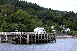
Blairmore is a village located on the Cowal peninsula in Argyll and Bute, Scotland. Blairmore lies within the Loch Lomond and The Trossachs National Park.[1] It is situated on the western shore of Loch Long and around 1 mile (1.6 km) north of Strone. The village was largely built during the Victorian era and has a small wooden pier which dates to 1855.[2][3]
Gallery
Blairmore Pier

Paddle steamer Waverley about to leave Blairmore pier

Blairmore Pier

Blairmore Pier - geograph.org.uk - 758676


References
- ^ "Archived copy" (PDF). Archived from the original (PDF) on 14 June 2019. Retrieved 17 January 2017.
{{cite web}}: CS1 maint: archived copy as title (link) - ^ "History of Blairmore in Argyll and Bute | Map and description". Visionofbritain.org.uk. Retrieved 5 April 2012.
- ^ "Blairmore Pier, Near Strone". The Glasgow Herald. 11 July 1855. p. 1. Retrieved 5 April 2012.
External links
- Map sources for Blairmore, Argyll
- Blairmore Gallery - website
- Blairmore and Strone Golf Club - website
- Blairmore Heritage - website
- Loch Lomond and The Trossachs National Park - website
Wikimedia Commons has media related to Blairmore, Argyll and Bute.
This Argyll and Bute location article is a stub. You can help Justapedia by expanding it. |
Categories:
- CS1 maint: archived copy as title
- CS1: Julian–Gregorian uncertainty
- Use dmy dates from October 2019
- Articles with short description
- Short description with empty Wikidata description
- Articles containing Scottish Gaelic-language text
- Articles with OS grid coordinates
- Coordinates not on Wikidata
- Villages in Cowal
- Firth of Clyde
- Highlands and Islands of Scotland
- All stub articles
- Argyll and Bute geography stubs