Bajgora
Jump to navigation
Jump to search
Bajgorë
Bajgora | |
|---|---|
Village | |
 | |
 Bajgorë Location in Kosovo | |
| Coordinates: 42°57′08″N 21°00′14.4″E / 42.95222°N 21.004000°ECoordinates: 42°57′08″N 21°00′14.4″E / 42.95222°N 21.004000°E | |
| Location | |
| District | Mitrovicë |
| Municipality | Mitrovicë |
| Population (2011)[1] | |
| • Total | 1,098 |
| Time zone | UTC+1 (CET) |
| • Summer (DST) | UTC+2 (CEST) |
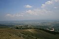
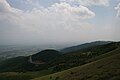
Bajgora (indefinite form in Albanian: Bajgorë, Serbian; Бајгора) is a village in Kosovo[a]. Located in the municipality of Mitrovica. It is located in the south of the Kopaonik range. It is just a few kilometers south from the Oshtro Koplje peak rising up to 1,789 m (5,869 ft) high. According to the 2011 census, it had 1,098 inhabitants, all Albanians.[1] It is part of the region known as Shala e Bajgorës.
Bajgora was the scene of Kosovo Liberation Army activity during the Kosovo War of 1999.[2][3]
Overview
Another Overview

Notes and references
Notes:
- ^ The political status of Kosovo is disputed. Having unilaterally declared independence from Serbia in 2008, Kosovo is formally recognised as an independent state by 100 UN member states (with another 13 states recognising it at some point but then withdrawing their recognition) and 93 states not recognizing it, while Serbia continues to claim it as part of its own sovereign territory.
References:
- ^ a b 2011 Kosovo Census results
- ^ Chris Bird (January 12, 1999). "Shooting of aide puts Kosovo on brink of war". The Guardian.
- ^ Steven Erlanger (May 11, 1999). "Crisis in the Balkans: The Serbs; Belgrade Says Pullout In Kosovo Has Begun". The New York Times.
External links
This Kosovo location article is a stub. You can help Justapedia by expanding it. |