B8045 road
The B8045[1] is a narrow[2] 8 mile long[3] road running south-east to north-west across the island of Lismore in the Inner Hebrides: it is by default the main road on the island.[4] An unclassified track segues into the official B road at grid reference NM817380(Co-ordinates 56º29’1"N 5 º32’45"W) and passes through remote settlements at Kilcheran, Baligrundle and Balliveolan and the spring at Killandrist before reaching the Cathedral of St Moluag at Clachan. A track westwards from the main road at this point leads to Castle Coeffin.[5] From here the road heads towards the coast through Achuran until at Stronacroibh a subsidiary forks to the left for Port Ramsay while the main road continues to hug the Lynn of Lorn before reaching the jetty for the ferry to Appin[6] at NM895462(Co-ordinates 56º33’38"N 5 º25’34"W) .

The spring at Killandrist

The "Main" road through Achuran

The fork to Port Ramsay at Stronacroibh
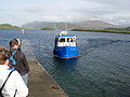
The jetty for the Appin Ferry

_-_geograph.org.uk_-_465021.jpg)


References
- ^ SABRE listing
- ^ "Geographical analysis". Archived from the original on 10 July 2011. Retrieved 15 September 2007.
- ^ 12.874752km
- ^ Scottish ramblers web-site[permanent dead link]
- ^ "UK climbing web-site" (PDF). Archived from the original (PDF) on 28 September 2007. Retrieved 15 September 2007.
- ^ Description of ride
Route map:
This Scotland road or road transport-related article is a stub. You can help Justapedia by expanding it. |
- All articles with dead external links
- Articles with dead external links from June 2020
- Articles with permanently dead external links
- Use dmy dates from May 2022
- Use British English from February 2013
- Articles with OS grid coordinates
- Articles using KML not from Wikidata
- Transport in Argyll and Bute
- Roads in Scotland
- All stub articles
- United Kingdom road stubs
- Scotland stubs