Ain Mohammed
Ain Mohammed
عين محمد | |
|---|---|
Abandoned village | |
 Ain Mohammed Location in Qatar | |
| Coordinates: 26°00′14″N 51°03′15″E / 26.003756°N 51.054056°ECoordinates: 26°00′14″N 51°03′15″E / 26.003756°N 51.054056°E | |
| Country | |
| Municipality | Al Shamal |
| Zone | Zone 78 |
| District no. | 410 |
| Area | |
| • Total | 3.7 sq mi (9.6 km2) |
Ain Mohammed (Arabic: عين محمد) is an abandoned village in Qatar, located in the municipality of Ash Shamal.[2] It is located about 1.5 km southwest of the abandoned village of Freiha. To the north is a series of small hills known as Al Jebailat.[3]
Etymology
Named after a local well, the first constituent of the village's name, "ain", refers to a natural source of water in Arabic. "Mohammed" was the name of the individual who built the well which supplied water to the village.[3]
History
In 1908, J.G. Lorimer recorded Ain Mohammed in his Gazetteer of the Persian Gulf, giving its location as "2 miles north-east of Zubarah". He makes note of a masonry well, 3 fathoms deep, yielding indifferent water, and a ruined fort.[4]
Archaeology
Rock carvings have been discovered at Ain Mohammed.[2]
Gallery

Site of the Ain Mohammed well which the village was named after

Ruined houses in Ain Mohammed
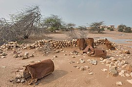
Remains of an oildrum fence for a farm in a depression in Ain Mohammed
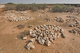
Old Ain Mohammed Cemetery.


References
- ^ "District Area Map". Ministry of Development Planning and Statistics. Retrieved 20 May 2019.
- ^ a b "Qatar National Development Strategy 2011–2016" (PDF). Qatar General Secretariat for Development Planning. March 2011. p. 208. Retrieved 6 July 2018.
- ^ a b "GIS Portal". Ministry of Municipality and Environment. Retrieved 6 July 2018.
- ^ "'Gazetteer of the Persian Gulf. Vol. II. Geographical and Statistical. J G Lorimer. 1908' [1524] (1639/2084)". Qatar Digital Library. Retrieved 6 July 2018. This article incorporates text from this source, which is in the public domain.
Capital: Madinat ash Shamal | |||||
| Zone 77 |
| ||||
| Zone 78 |
| ||||
| Zone 79 |
| ||||
This Qatari location article is a stub. You can help Justapedia by expanding it. |