Žeimiai Eldership
Jump to navigation
Jump to search
Žeimiai Eldership
Žeimių seniūnija | |
|---|---|
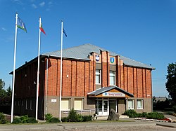
 Žeimiai Eldership office | |
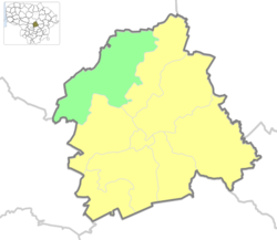
 Location of Žeimiai eldership | |
| Coordinates: 55°11′N 24°10′E / 55.183°N 24.167°ECoordinates: 55°11′N 24°10′E / 55.183°N 24.167°E | |
| Country | |
| Ethnographic region | Aukštaitija |
| County | |
| Municipality | |
| Administrative centre | Žeimiai |
| Area | |
| • Total | 152 km2 (59 sq mi) |
| Population (2011) | |
| • Total | 2,238 |
| • Density | 15/km2 (38/sq mi) |
| Time zone | UTC+2 (EET) |
| • Summer (DST) | UTC+3 (EEST) |
Žeimiai Eldership (Lithuanian: Žeimių seniūnija) is a Lithuanian eldership, located in a northern part of Jonava District Municipality.[1] As of 2020, administrative centre and largest settlement within eldership was Žeimiai.[2]
Populated places
Following settlements are located in the Žeimiai Eldership (as for 2011 census):[3]
- Towns: Žeimiai
- Villages: Akliai, Akmeniai, Barsukinė, Biliuškiai, Blauzdžiai, Drobiškiai, Gireliai, Jagėlava, Juljanava, Juškonys, Kuigaliai, Liepkalnis, Martyniškis, Milašiškiai, Mimaliai, Mitėniškiai, Naujasodis, Naujokai, Normainėliai, Normainiai, Normainiai II, Paduobiai, Palankesiai, Pamelnytėlė, Pauliukai, Pročkai, Pėdžiai, Skrynės, Svalkeniai, Terespolis, Varpėnai, Zofijauka, Žieveliškiai
- Railway settlements: Žeimiai GS
References
- ^ "Žeimių seniūnija - Seniūnijos". lrvalstybe.lt. Retrieved 31 December 2020.
- ^ "Žeimių seniūnija". jonava.lt. Retrieved 31 December 2020.
- ^ "2011 census". Statistikos Departamentas (Lithuania). Retrieved August 21, 2017.
