Štipoklasy
Jump to navigation
Jump to search
Štipoklasy | |
|---|---|
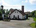
 Centre of Štipoklasy | |
 Štipoklasy Location in the Czech Republic | |
| Coordinates: 49°49′29″N 15°12′48″E / 49.82472°N 15.21333°ECoordinates: 49°49′29″N 15°12′48″E / 49.82472°N 15.21333°E | |
| Country | |
| Region | Central Bohemian |
| District | Kutná Hora |
| First mentioned | 1385 |
| Area | |
| • Total | 3.79 km2 (1.46 sq mi) |
| Elevation | 470 m (1,540 ft) |
| Population (2022-01-01)[1] | |
| • Total | 150 |
| • Density | 40/km2 (100/sq mi) |
| Time zone | UTC+1 (CET) |
| • Summer (DST) | UTC+2 (CEST) |
| Postal code | 284 01 |
| Website | www |
Štipoklasy is a municipality and village in Kutná Hora District in the Central Bohemian Region of the Czech Republic. It has about 200 inhabitants.
Gallery

Eastern part of Štipoklasy
Municipal office


References
Wikimedia Commons has media related to Štipoklasy.
This Central Bohemian Region location article is a stub. You can help Justapedia by expanding it. |