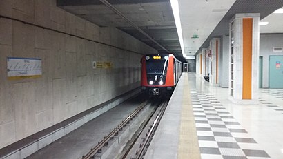
İSTOÇ (Istanbul Metro)
Jump to navigation
Jump to search
This article needs additional citations for verification. (October 2016) |
| Istanbul Metro rapid transit station | |||||||||||
 | |||||||||||
| General information | |||||||||||
| Coordinates | 41°03′53″N 28°49′34″E / 41.064837°N 28.826017°ECoordinates: 41°03′53″N 28°49′34″E / 41.064837°N 28.826017°E | ||||||||||
| Owned by | Istanbul Metropolitan Municipality | ||||||||||
| Line(s) | |||||||||||
| Platforms | 1 island platform | ||||||||||
| Tracks | 2 | ||||||||||
| Connections | |||||||||||
| Construction | |||||||||||
| Structure type | Underground | ||||||||||
| Disabled access | Yes | ||||||||||
| History | |||||||||||
| Opened | 14 June 2013[1] | ||||||||||
| Electrified | 1,500 V DC Overhead line | ||||||||||
| Services | |||||||||||
| |||||||||||
İSTOÇ is an underground rapid transit station on the M3 line of the Istanbul Metro.[2] It is located in the northwestern tip of Bağcılar under the Istanbul Wholesalers Market (Turkish: İstanbul Toptancılar Çarşısı, shortened as İSTOÇ[3]). Opened on 14 June 2013 it has an island platform serviced by two tracks.
Layout
| Northbound | ← | |
| Island platform | ||
| Southbound | ||
References
- ^ "M3 Kirazlı-Olimpiyat-Başakşehir Metro Line". Metro İstanbul A.Ş. Retrieved 2020-05-07.
- ^ "Istanbul Metro Map". Turkey Travel Planner. Retrieved 2019-11-02.
- ^ "What İSTOÇ stands for". Archived from the original on 2016-10-27.
Categories:
- Pages with short description
- Articles with short description
- Short description with empty Wikidata description
- Articles needing additional references from October 2016
- All articles needing additional references
- Coordinates not on Wikidata
- All articles with unsourced statements
- Articles with unsourced statements from February 2022
- Articles containing Turkish-language text
- Railway stations opened in 2013
- Istanbul metro stations
- Başakşehir
- All stub articles
- Istanbul metro stubs
- Turkish railway station stubs