Woninjae station
(Redirected from Woninjae Station)
This article needs additional citations for verification. (October 2020) |
Woninjae (Incheon Himchan Hospital) | |||||||||||||||||||||||||
|---|---|---|---|---|---|---|---|---|---|---|---|---|---|---|---|---|---|---|---|---|---|---|---|---|---|
 | |||||||||||||||||||||||||
| Korean name | |||||||||||||||||||||||||
| Hangul | |||||||||||||||||||||||||
| Hanja | |||||||||||||||||||||||||
| Revised Romanization | Woninjaeyeok | ||||||||||||||||||||||||
| McCune–Reischauer | Wŏninjaeyŏk | ||||||||||||||||||||||||
| General information | |||||||||||||||||||||||||
| Location | 119-4 Yeonsu-dong, Yeonsu-gu, Incheon | ||||||||||||||||||||||||
| Operated by | Incheon Transit Corporation, Korail | ||||||||||||||||||||||||
| Line(s) | Incheon Line 1 Suin–Bundang Line | ||||||||||||||||||||||||
| Platforms | 4 | ||||||||||||||||||||||||
| Tracks | 4 | ||||||||||||||||||||||||
| Construction | |||||||||||||||||||||||||
| Structure type | Underground (Line 1) Aboveground (Suin Line) | ||||||||||||||||||||||||
| Bicycle facilities | Yes | ||||||||||||||||||||||||
| Key dates | |||||||||||||||||||||||||
| October 6, 1999 | Incheon Line 1 opened | ||||||||||||||||||||||||
| June 30, 2012 | Suin–Bundang Line opened | ||||||||||||||||||||||||
| Passengers | |||||||||||||||||||||||||
| 2017 | |||||||||||||||||||||||||
| Services | |||||||||||||||||||||||||
| |||||||||||||||||||||||||
Woninjae Station is a commuter train station on Line 1 of the Incheon Subway and the Suin Line of the Seoul Metropolitan Subway systems. The station became a transfer point to the above-ground Suin Line in July 2012. The station has two platforms that requires walking some distance for switching trains.
Exits
| Exit No. | Image | Destinations |
|---|---|---|
| 1 | Kookmin bank Namdong industrial complex | |
| 2 | Namdong industrial complex | |
| 3 | Yeonsu police office Yeonsu telecommunications office Yeonhwa elementary school Yeonsu high school Downtown Yeonsu-gu | |
| 4 | Joongang elementary school Yeonsu middle school | |
| 5 | Seonggi Village Residents' Meeting | |
| 6 | Seonggi Village Residents' Meeting |
Gallery
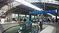
Platform area in Woninjae Station

Interior in Woninjae Station

Incheon Subway Line 1 station sign

Suin Line station sign


References
Wikimedia Commons has media related to Woninjae station.
- ^ "코레일 > 사업분야 > 광역철도사업 > 수송통계 > 자료실" [KORAIL> Business Areas> Regional Railroad Projects> Transportation Statistics> Archives] (in Korean). Korail.
- ^ "제목=인천교통공사 > 알림마당 > 자료실 > 일반 자료실" [“Incheon Transportation Corporation> Notification Center> Archives> General Archives”] (in Korean). 2016-09-10. Archived from the original on 2016-07-30. Retrieved 2016-07-30.
Coordinates: 37°24′44.66″N 126°41′16.46″E / 37.4124056°N 126.6879056°E
This Seoul Metropolitan Subway station article is a stub. You can help Justapedia by expanding it. |
Categories:
- CS1 Korean-language sources (ko)
- Articles needing additional references from October 2020
- All articles needing additional references
- Articles containing Korean-language text
- Articles using Infobox station with markup inside name
- Pages with no open date in Infobox station
- Commons category link is the pagename
- Coordinates not on Wikidata
- Metro stations in Incheon
- Seoul Metropolitan Subway stations
- Railway stations in South Korea opened in 1999
- Yeonsu District
- All stub articles
- Seoul metro station stubs