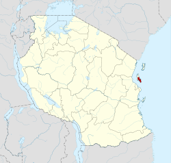
Unguja South Region
Unguja South Region | |
|---|---|
| Nickname: Wild Zanzibar | |
 Location in Tanzania | |
| Coordinates: 6°15′51.48″S 39°26′42″E / 6.2643000°S 39.44500°ECoordinates: 6°15′51.48″S 39°26′42″E / 6.2643000°S 39.44500°E | |
| Country | |
| Named for | Unguja Island |
| Capital | Koani |
| Districts | List
|
| Area | |
| • Total | 854 km2 (330 sq mi) |
| • Rank | 29th of 31 |
| Population (2012) | |
| • Total | 94,504 |
| • Rank | 31st of 31 |
| • Density | 110/km2 (290/sq mi) |
| Demonym | South Zanzibari |
| Ethnic groups | |
| • Settler | Swahili |
| • Native | Hadimu |
| Time zone | UTC+3 (EAT) |
| Postcode | 72xxx |
| Area code | 024 |
| ISO 3166 code | TZ-11 [1] |
| HDI (2018) | 0.612[2] medium · 4th |
| Website | Official website |
| Symbols | |
| Mammal | Spinner dolphin |
| Bird | Pemba white-eye |
| Fish | Powder blue surgeonfish |
| Butterfly | African grass blue |
| Tree | Black mangrove |
| Mineral | Coral |
Unguja South Region, Zanzibar South Region or South Zanzibar Region (Mkoa wa Unguja Kusini in Swahili) is one of the 31 regions of Tanzania. The region covers an area of 854 km2 (330 sq mi).[3] The region is comparable in size to the combined land area of the nation state of Kiribati.[4] and the administrative region is located entirely on the island of Zanzibar. Unguja South Region is bordered on three sides to the south by Indian Ocean, northeast by Unguja North Region and northwest by Mjini Magharibi Region. The regional capital is the town of Koani.[5] According to the 2012 census, the region has a total population of 94,504.[6]
Administrative divisions
Districts
Unguja South Region is divided into two districts, each administered by a council:
| Districts of Unguja South Region | ||
|---|---|---|
| Map | District | Population (2012) |

|
Kati District | 76,346 |
| Kusini District | 39,242 | |
| Total | 115,588 | |
Constituencies
For parliamentary elections, Tanzania is divided into constituencies. As of the 2010 elections Zanzibar Central/South Region had five constituencies:[7]
- Kati District
- Chwaka Constituency
- Koani Constituency
- Uzini Constituency
- Kusini District
- Makunduchi Constituency
- Muyuni Constituency
References
- ^ "ISO 3166". ISO. Retrieved 2022-07-10.
- ^ "Sub-national HDI - Area Database - Global Data Lab". hdi.globaldatalab.org. Retrieved 2020-02-26.
- ^ "Unguja South Region Size". Retrieved 22 July 2022.
- ^ 811 km2 (313 sq mi) for Kiribati at "Area size comparison". Nations Online. 2022. Retrieved 22 July 2022.
- ^ "Unguja South's capital". 2022. Retrieved 22 July 2022.
- ^ "2012 Population and Housing Census General Report" (PDF). Government of Tanzania. Retrieved 2022-07-22.
- ^ "Organisations located in Zanzibar South Region - Tanzania". African Development Information.
External links


