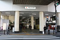
Toritsu-Daigaku Station
(Redirected from Toritsudaigaku Station)
This article needs additional citations for verification. (July 2022) |
 Entrance in February 2009 | |
| General information | |
| Location | 3-2 Takaban, Meguro, Tōkyō 152-0004 Japan |
| Operated by | |
| Line(s) | |
| Distance | 5.6 km from Shibuya |
| Platforms | 2 |
| Tracks | 2 |
| Construction | |
| Structure type | Elevated |
| Other information | |
| Station code | TY06 |
| Website | Official website |
| History | |
| Opened | 28 August 1927 |
| Passengers | |
| 40,570 daily (2021) | |
| Location | |
Toritsu-Daigaku Station (都立大学駅, Toritsudaigaku-eki) is a Tōkyū Tōyoko Line station located in Meguro Ward, Tōkyō.
Station layout
This elevated station consists of two opposite side platforms serving two tracks. This local station can only accommodate 8-car length trains.[1]
| 1 | ■ Tokyu Toyoko Line | for Jiyūgaoka, Musashi-Kosugi, Kikuna, and Yokohama |
| 2 | ■ Tokyu Toyoko Line | for Naka-Meguro and Shibuya |
History
Toritsu-Daigaku Station opened on 28 August 1927 as Kakinokizaka Station.[2] It gained its current name in 1952.[2]
Adjacent stations
| « | Service | » | ||
|---|---|---|---|---|
| Tōkyu Tōyoko Line[3] | ||||
| Gakugei-daigaku | Local | Jiyūgaoka | ||
| Express: Does not stop at this station | ||||
| Commuter Exp.: Does not stop at this station | ||||
| Limited Exp.: Does not stop at this station | ||||
References
- ^ "Tōkyū Corporation - Toritsu-Daigaku Station" (in Japanese). Archived from the original on 12 February 2013. Retrieved 25 July 2022.
- ^ a b Miyata, Michikazu (2008). 東急の駅 今昔・昭和の面影 [Tokyu Stations Then and Now, Showa Remnants] (in Japanese). Japan: JTB Publishing (published 1 September 2008). p. 47. ISBN 978-4-53-307166-9.
- ^ "Tōkyū Corporation - Tōyoko Line Guide" (in Japanese). Archived from the original on 14 October 2008. Retrieved 17 December 2011.
Coordinates: 35°37′04″N 139°40′35″E / 35.617833°N 139.676389°E
Categories:
- CS1 Japanese-language sources (ja)
- Articles with short description
- Use dmy dates from July 2022
- Articles needing additional references from July 2022
- All articles needing additional references
- Official website not in Wikidata
- Articles using Infobox station with a broken location map
- Articles using Infobox station with markup inside name
- Articles using Infobox station with links or images inside name
- Articles containing Japanese-language text
- Internal link templates linking to redirects
- Coordinates not on Wikidata
- Tokyu Toyoko Line
- Stations of Tokyu Corporation
- Railway stations in Tokyo
- All stub articles
- Tokyo railway station stubs


