Saint John Parish, Antigua and Barbuda
This article needs additional citations for verification. (July 2016) |
Parish of Saint John[1] | |
|---|---|
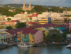
 Saint John's, the capital of Saint John Parish. | |
![Location of Parish of Saint John[1]](https://upload.wikimedia.org/wikipedia/commons/thumb/b/bd/Saint_John_in_Antigua_and_Barbuda_%28cropped%29.svg/250px-Saint_John_in_Antigua_and_Barbuda_%28cropped%29.svg.png) | |
| Country | Antigua and Barbuda |
| Island | Antigua |
| Established | 17th December, 1873[2] |
| Capital | St. John's |
| Area | |
| • Total | 74 km2 (28.5 sq mi) |
| Population (2018 estimate)[3] | |
| • Total | 56,736 |
| • Density | 770/km2 (2,000/sq mi) |
| Demonym | Saint Johnstonian |
| Time zone | UTC-4 (AST) |
Saint John is a civil parish of Antigua and Barbuda, located on the island of Antigua. It is the most populous parish of Antigua and Barbuda, with a population of 51,737 in 2011,[4] and an estimated population of 56,736 in 2018.[5] The majority of the population of the parish is located within the country’s capital, St. John’s.
Boon Point, the northernmost point of Antigua, is located in Saint John.
The parish annexed Redonda in 1872.[6]
Populated places
The parish contains the nation's capital city of St. John's. Other populated places include:
- Aberdeen
- Adelin
- Barrymore
- Branns Hamlet
- Belmont
- Bellevue Heights
- Bendals
- Blue Waters
- Buckleys
- Cedar Grove
- Cedar Valley
- Clare Hall
- Clarkes Hill
- Cooks Hill
- Cooks New Extension
- Creekside
- Crosbies
- Deanery
- Emanuel
- Five Islands
- Gambles
- Gamble's Terrace
- Golden Grove
- Gray Hill
- Grays Farm
- Green Bay
- Green Castle
- Hodges Bay
- Jacks Hill
- Marble Hill
- McKinnon’s
- Montclear
- Nut Grove
- Obeez
- Ottos
- Piggott's Ville
- Potters Village
- Prison Farm
- Radio Range
- Renfrew
- St. Claire
- Skerritts
- Sutherlands
- Tomlinson
- Union Road
- Upper Gamble's
- Villa
- Weatherhills
- Yeptons
- Yorks
Demographics
Main Articles: Demographics of Saint John's (Antigua and Barbuda), Demographics of Saint John Parish, Antigua and Barbuda
Education
Island Academy International, the sole international school in the country, is located in the town of Buckleys within Saint John Parish.[7][8] It was formerly Oliver's Estate Island Academy.[9]
References
- ^ http://laws.gov.ag/wp-content/uploads/2018/08/cap-304.pdf[bare URL PDF]
- ^ http://laws.gov.ag/wp-content/uploads/2018/08/cap-304.pdf[bare URL PDF]
- ^ "Antigua and Barbuda 2018 Labour Force Survey Report" (PDF). Antigua & Barbuda Statistics Division (statistics.gov.ag). October 2020. Retrieved 2022-09-03.
Table 6.2.1
- ^ "Antigua and Barbuda 2011 Population and Housing Census: A Demographic Profile" (PDF). Antigua & Barbuda Statistics Division (statistics.gov.ag). June 2017. Retrieved 2022-09-01.
- ^ "Antigua and Barbuda 2018 Labour Force Survey Report" (PDF). Antigua & Barbuda Statistics Division (statistics.gov.ag). October 2020. Retrieved 2022-09-03.
Table 6.2.1
- ^ "Chapter 373: The Redonda Annexation Act". Laws of Antigua & Barbuda (PDF). Antigua & Barbuda Ministry of Legal Affairs (laws.gov.ag).
- ^ Island Academy International.com: website (Webcitation.org: Archive of Island Academy International homepage) . retrieved on September 29, 2015.
- ^ Island Academy International.com: Directions & Map
- ^ Webcitation.org: Archive - Oliver's Estate Island Academy, "Oliver's Estate PO Box W1884, Buckley's Main Rd, Buckleys, Antigua & Barbuda" . retrieved on September 29, 2015.
Coordinates: 17°7′N 61°50′W / 17.117°N 61.833°W
- All articles with bare URLs for citations
- Articles with bare URLs for citations from March 2022
- Articles with PDF format bare URLs for citations
- Articles needing additional references from July 2016
- All articles needing additional references
- Articles with short description
- Pages using infobox settlement with no coordinates
- Coordinates not on Wikidata
- AC with 0 elements
- Saint John Parish, Antigua and Barbuda
- Parishes of Antigua and Barbuda
- Antigua (island)
- All stub articles
- Antigua and Barbuda geography stubs