Newark and Sherwood
District of Newark and Sherwood | |
|---|---|
District | |
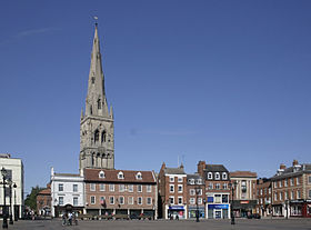
 Newark-on-Trent, the largest settlement and administrative centre of the district | |
 Shown within Nottinghamshire | |
| Sovereign state | United Kingdom |
| Constituent country | England |
| Region | East Midlands |
| Administrative county | Nottinghamshire |
| Admin. HQ | Newark-on-Trent[1] |
| Government | |
| • Type | Newark and Sherwood District Council |
| • Leadership: | Leader and committee system |
| • Executive: | Conservative |
| • MPs: | Robert Jenrick, Mark Spencer |
| Area | |
| • Total | 251.5 sq mi (651.3 km2) |
| • Rank | 61st |
| Population (mid-2019 est.) | |
| • Total | 122,421 |
| • Rank | Ranked 190th |
| • Density | 490/sq mi (190/km2) |
| Time zone | UTC+0 (Greenwich Mean Time) |
| • Summer (DST) | UTC+1 (British Summer Time) |
| ONS code | 37UG (ONS) E07000175 (GSS) |
| Ethnicity | 98.5% White |
| Website | www |


Newark and Sherwood is a local government district and is the largest district in Nottinghamshire, England. The district was formed on 1 April 1974, by a merger of the municipal borough of Newark with Newark Rural District and Southwell Rural District.
The district is predominantly rural, with some large forestry plantations, the ancient Sherwood Forest and the towns of Newark-on-Trent, Southwell and Ollerton. The council is based at Castle House, adjacent to Newark Castle Railway station, having previously used Kelham Hall in the nearby village of Kelham as its headquarters. [2][3]
Settlements
Newark-on-Trent, together with Balderton, forms the largest urban area in the district. Newark-on-Trent has many important historic features including Newark Castle, St Mary's Magdalene Church, Georgian architecture and a defensive earthwork from the British Civil Wars. Other important towns in the district include Ollerton and Southwell which is home to Southwell Minster and Southwell Racecourse. The village of Edwinstowe is claimed to be the birthplace of Robin Hood where he was born and was married at Church of St Mary. The south-eastern settlements are home to people who commute to Nottingham, Mansfield, Derby and Leicester. The north-eastern settlements are home to people who commute to Lincoln, Sleaford and Grantham. The north-western settlements are home to people who commute to Worksop, Retford, Gainsborough, Scunthorpe, Chesterfield, Sheffield, Rotherham and Doncaster.
Other settlements in the district include:
- Averham
- Balderton, Bathley, Bilsthorpe, Blidworth, Boughton, Brough
- Carlton-on-Trent, Caunton, Clipstone, Collingham, Cromwell
- Eakring, Edingley, Edwinstowe, Egmanton
- Farndon, Farnsfield, Fernwood, Fiskerton
- Gunthorpe
- Halam, Halloughton, Hawton, Hockerton
- Kelham, Kirklington, Kirton, Kneesall
- Laxton, Little Carlton, Lowdham
- Maplebeck, Morton
- North Muskham, Norwell
- Ossington, Oxton
- Perlethorpe
- Rainworth, Rolleston
- South Muskham, Sutton-on-Trent
- Thurgarton
- Upton
- Walesby, Wellow, Weston, Winkburn
Politics
Council
The district council has been controlled by the Conservatives since 2007, with David Lloyd being leader of the council since 2018. The last election in 2019 Newark and Sherwood District Council election saw the Conservatives win 27 of the 39 seats on the council, Labour 7 seats, independents 3 seats, and Liberal Democrats 2 seats.[4] The next elections are due in 2023.
Parliamentary constituencies
The district is divided into two parliamentary constituencies: Newark, created in 1885, which has been represented by Robert Jenrick, a Conservative, since 2014;[5] and has been held by the Conservative Party since 2001;[6] and Sherwood, created in 1983, represented by Mark Spencer, also a Conservative, since 2010.[7]
References
- ^ "Castle House". newark-sherwooddc.gov.uk. Newark and Sherwood District Council. Archived from the original on 14 June 2020. Retrieved 14 June 2020.
- ^ "Grade I-listed Kelham Hall conversion 'will create 80 jobs'". BBC News. 27 November 2014. Retrieved 6 August 2021.
- ^ "Kelham Hall sale confirmed by Newark council". BBC News. 25 June 2014. Retrieved 6 August 2021.
- ^ "Newark and Sherwood District Council: Election results for 2019". BBC News. Retrieved 20 August 2022.
- ^ "Newark by-election candidate names confirmed". BBC News. 13 May 2014. Retrieved 6 September 2021.
- ^ "Wayback Machine". 15 October 2011. Archived from the original on 15 October 2011. Retrieved 6 September 2021.
- ^ "Wayback Machine". 26 July 2013. Archived from the original on 26 July 2013. Retrieved 6 September 2021.
Coordinates: 53°06′N 0°57′W / 53.10°N 0.95°W
- Articles with short description
- Use British English from June 2020
- Use dmy dates from June 2020
- Pages using infobox settlement with no coordinates
- AC with 0 elements
- Coordinates not on Wikidata
- Newark and Sherwood
- Non-metropolitan districts of Nottinghamshire
- All stub articles
- Nottinghamshire geography stubs
- United Kingdom government stubs

