Rainbow Bridge (Niagara Falls)
Rainbow Bridge | |
|---|---|
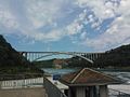
 Rainbow Bridge as seen from Canada, 2013 | |
| Carries | 4 lanes of |
| Crosses | Niagara River |
| Locale | Niagara Falls, Ontario, and Niagara Falls, New York |
| Official name | Niagara Falls International Rainbow Bridge |
| Maintained by | Niagara Falls Bridge Commission |
| Characteristics | |
| Design | Arch bridge |
| Total length | 1,450 ft (440 m)[1] |
| Height | 202 ft (62 m)[1] |
| Longest span | 960 ft (290 m)[1] |
| History | |
| Construction cost | $4 million[1] |
| Opened | November 1, 1941 |
| Statistics | |
| Toll | Canada-bound only: $5.00 USD or $6.50 CAD per auto. USA-bound only: $1.00 USD or $1.00 CAD per pedestrian/bicyclist.[2] |
The Niagara Falls International Rainbow Bridge, commonly known as the Rainbow Bridge, is an arch bridge across the Niagara River gorge. It connects the cities of Niagara Falls, New York, United States (to the east), and Niagara Falls, Ontario, Canada (west).
Construction
The Rainbow Bridge was built near the site of the earlier Honeymoon Bridge, which collapsed on January 27, 1938, due to an ice jam in the river. A joint Canadian and American commission had been considering a new bridge to replace it, and the collapse added urgency to the project.[citation needed]

A design by architect Richard (Su Min) Lee was chosen (and used again for the Lewiston-Queenston Bridge, approximately 10 kilometres (6 mi) downriver). The bridge's Rainbow Tower and Canadian plaza are the work of Canadian architect William Lyon Somerville.[3] King George VI and Queen Elizabeth, during their visit to Niagara Falls as part of the 1939 royal tour of Canada, dedicated the site of the Rainbow Bridge; a monument was erected to commemorate the occasion. Construction began in May 1940. The bridge officially opened on November 1, 1941.[4]
The origin of the bridge's name is unknown, with one possible source being T. B. McQuesten, then chairman of the Niagara Parks Commission. An engraving on the Canadian side of the bridge includes a biblical quote from the Book of Genesis which references a "bow in the clouds." Regardless of its origin, the NRBC used the name as early as March 1939.[5]
Description and specifications
The New York State Department of Transportation designates the bridge as NY 955A, an unsigned reference route, while the Ontario Ministry of Transportation designates it as part of Highway 420 (and the original routing of the Queen Elizabeth Way), even though it is separated from the rest of the route by a regional road. On the American side, a number of state and national routes end at a set of intersections in front of the bridge. New York routes 104 and 384, as well as the northern section of the Niagara Scenic Parkway, all terminate at the final intersection before the bridge, and none of the designations passes onto the bridge. U.S. Route 62 terminates two blocks north at route 104, which then continues to the bridge. The Rainbow Tower, part of the plaza complex on the Canadian side, houses a large carillon, which plays several times daily.
The bridge permits no commercial trucks; the nearest border crossing for these is the Lewiston-Queenston Bridge.[6]
Tolls
For each pedestrian or bicyclist, the toll to cross the bridge is $1.00 USD or CAD. The pedestrian toll is collected by an automatic turnstile when leaving Canada, payable in USD or CAD quarters or $1 CAD 'loonies'.[2] Change machines are available from $1 and $5 USD bills and $1 (loonies) and $2 (toonies) CAD coins.
For personal automobiles, the toll is only collected when leaving the United States and entering Canada. As of August 2022, car tolls are $5.00 USD or $6.50 CAD.
Gallery
The bridge as viewed from the Canadian side, with collapsed Schoellkopf Power Station visible distant cliff face

Bridge and falls at night
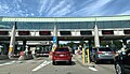
The border station to enter Canada after crossing the bridge from the US


_Border_Station.jpg)
Cityscape

See also
- List of crossings of the Niagara River
- List of reference routes in New York
- List of bridges in Canada
- List of bridges in the United States by height
References
- ^ a b c d "Celebrating Eight Decades of Award-winning Bridges" (PDF). Modern Steel Construction. American Institute of Steel Construction. November 2011. p. 23 (page 2 in PDF). Retrieved April 30, 2019.
- ^ a b "Niagara Falls Bridge Commission: Toll Cost & Vehicle Definitions".
- ^ "Somerville, William Lyon". Biographical Dictionary of Architects in Canada 1800–1950. Retrieved August 23, 2017.
- ^ Woyce, Kevin (2015). Niagara: The Falls and the River: An Illustrated History. Kevin Woyce. ISBN 978-0692522523.
- ^ Stamp, Robert M. (1992). Bridging the Border: Structures of Canadian–American Relations. Toronto: Dundurn Press. p. 128. ISBN 1-55002-074-9.
- ^ "Niagara Falls Bridge Commission: Which Bridge Do I Take?".
External links
- Niagara Falls Bridge Commission
- Google Maps view of Rainbow Bridge
- Live Traffic Camera of Rainbow Bridge
- Images from the Historic Niagara Digital Collections
- Rainbow Bridge at Structurae
Bridges of the Niagara River | ||||
|---|---|---|---|---|
| ||||
Coordinates: 43°5′24.84″N 79°4′3.88″W / 43.0902333°N 79.0677444°W
- Articles with short description
- All articles with unsourced statements
- Articles with unsourced statements from June 2017
- Commons category link is defined as the pagename
- Structurae ID not in Wikidata
- Coordinates not on Wikidata
- 1941 establishments in New York (state)
- 1941 establishments in Ontario
- Bridges completed in 1941
- Bridges in Niagara Falls, New York
- Bridges in Niagara Falls, Ontario
- Bridges over the Niagara River
- Canada–United States border crossings
- Open-spandrel deck arch bridges in Canada
- Open-spandrel deck arch bridges in the United States
- Road bridges in New York (state)
- Road bridges in Ontario
- Toll bridges in Canada
- Toll bridges in New York (state)
- Steel bridges in Canada
- Steel bridges in the United States
- Concrete bridges in Canada
- Concrete bridges in the United States