National Highway 79 (India)
 | ||||
|---|---|---|---|---|
 Map of the National Highway in red | ||||
 | ||||
| Route information | ||||
| Part of | ||||
| Length | 134.2 km (83.4 mi) | |||
| Major junctions | ||||
| West end | Salem, Tamil Nadu | |||
| East end | Ulundurpettai, Villupuram district, Tamil Nadu | |||
| Location | ||||
| Country | India | |||
| States | Tamil Nadu | |||
| Primary destinations | Ulundrupet - Kallakurichi - Chinnasalem - Attur - Pethanaickenpalayam - Vazhapadi - Salem | |||
| Highway system | ||||
| ||||
National Highway 79 (NH 79) is a National Highway in India entirely within the state of Tamil Nadu.[1] It runs between Ulundurpettai and Salem in the Indian state of Tamil Nadu for a total of 134 km (83 mi).[2] It connects with NH 44 and NH 544 at Salem. NH 79 connects NH 68 and SH 69 at Ulundurpettai and SH 6 at kallakurichi. It was upgraded to a dual carriageway road in two phases on a Build-operate-transfer basis by Reliance Infrastructure and Maytas.[3]
Traffic
NH 79 is an important connecting road for vehicles travelling from the two major cities of Coimbatore and Kochi. NH 79 directly connects Salem with Chennai, and indirectly Coimbatore, Erode, Tirupur and the cities around these areas.
Route
Ulundurpettai - Elavanasur kottai - Thiyagadurgam - Kallakurichi - Chinnasalem, Thalaivasal - Kattukottai - Attur - Pethanaickenpalayam - Vazhapadi - Salem.[4]
Junctions list
This article contains a bulleted list or table of intersections which should be presented in a properly formatted junction table. (November 2021) |
 NH 44 Terminal near Salem.[1]
 NH 179A near Salem
 NH 136 near Attur
 NH 532 near Chinnasalem
 NH 38 Terminal near Ulundurpettai.[1]
Gallery
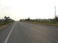
NH 79 near Kallakurichi in Villupuram district, Tamil Nadu.

NH 79 near Kallakurichi, Villupuram district, Tamil Nadu

See also
- List of National Highways in India
- List of National Highways in India by state
- National Highways Development Project
References
- ^ a b c "New Numbering of National Highways notification - Government of India" (PDF). The Gazette of India. Retrieved 13 April 2019.
- ^ "National Highways Starting and Terminal Stations". Ministry of Road Transport & Highways. Retrieved 2 December 2012.
- ^ R, Ilangovan (19 March 2009). "Satyam fiasco affects NH-79works". The Hindu. Salem. Archived from the original on 19 November 2009. Retrieved 13 May 2012.
- ^ "State-wise length of National Highways (NH) in India". Ministry of Road Transport and Highways India. Retrieved 13 April 2019.
NH79 Frequent accidents fatal and major accidents are ver often between the kattukottai bridge and Adayar Ananada bhavan.In this week alone 7 accidents occurred. Recently in July 2022 the roads were overlaid.As a result,the level of thar road got higher and mud road lower.As a result, two wheelers when sidelined by over speeding four wheelers,lost their balance and fell down with fractures. Myself is a victim in March 2019. It has been more than a month the imbalance between the thar road and mud road remains unrectified. A slope has to be made immediately to avoid more accidents like that.Please attend this immediately. Elango k Advocate 9444178379
External links


Secondary routes of National Highway 79 | ||
|---|---|---|
| ||
| Secondary Routes of NH 79 | ||
This article about a National Highway in India is a stub. You can help Justapedia by expanding it. |
- Articles with short description
- Use dmy dates from March 2017
- Use Indian English from March 2017
- All Justapedia articles written in Indian English
- Infobox road articles without wikidata country
- Infobox road articles without wikidata instance of
- Infobox road instances in India
- Wikipedia articles needing a junction list from November 2021
- Articles with invalid date parameter in template
- All pages needing cleanup
- National highways in India
- National Highways in Tamil Nadu
- All stub articles
- Indian National Highway stubs
- Pages using the Kartographer extension