Kékes
(Redirected from Monastery of Kékes)
| Kékes | |
|---|---|
 | |
| Highest point | |
| Elevation | 1,014 m (3,327 ft)[1] |
| Prominence | 774 m (2,539 ft)[1] |
| Listing | Country high point |
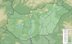
| Coordinates | 47°52′44″N 20°0′37″E / 47.87889°N 20.01028°ECoordinates: 47°52′44″N 20°0′37″E / 47.87889°N 20.01028°E |
| Naming | |
| English translation | Bluish |
| Language of name | Hungarian |
| Geography | |
| Location | Heves county, Hungary |
| Parent range | Mátra, Western Carpathians |
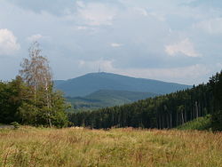
Kékes [ˈkeːkɛʃ] is Hungary's highest mountain, at 1,014 metres (3,327 ft) above sea level.[1] It lies 12 kilometres (7.5 mi) northeast of Gyöngyös,[2] in the Mátra range of Heves county. It is Hungary's third most popular tourist attraction, after Lake Balaton and the Danube, and has a number of hotels and skiing pistes. The Kékestető TV Tower stands at the summit.
The name Kékes is derived from the mountain's often bluish colour. In Hungarian, the word kék means 'blue', while kékes means implicitly 'bluish'.
History
It is home to the former Pauline Monastery of Kékes.
Climate
| Climate data for Kékestető (1991−2020 normals, extremes 1980−present) | |||||||||||||
|---|---|---|---|---|---|---|---|---|---|---|---|---|---|
| Month | Jan | Feb | Mar | Apr | May | Jun | Jul | Aug | Sep | Oct | Nov | Dec | Year |
| Record high °C (°F) | 12.2 (54.0) |
13.9 (57.0) |
17.3 (63.1) |
22.4 (72.3) |
25.6 (78.1) |
29.7 (85.5) |
31.4 (88.5) |
29.8 (85.6) |
25.8 (78.4) |
20.6 (69.1) |
17.4 (63.3) |
12.5 (54.5) |
31.4 (88.5) |
| Mean maximum °C (°F) | 6.0 (42.8) |
7.3 (45.1) |
12.0 (53.6) |
18.1 (64.6) |
21.7 (71.1) |
24.9 (76.8) |
26.6 (79.9) |
26.2 (79.2) |
20.9 (69.6) |
16.9 (62.4) |
11.6 (52.9) |
6.3 (43.3) |
27.4 (81.3) |
| Average high °C (°F) | −1.7 (28.9) |
−0.3 (31.5) |
3.5 (38.3) |
10.2 (50.4) |
14.8 (58.6) |
18.1 (64.6) |
20.0 (68.0) |
20.0 (68.0) |
14.5 (58.1) |
9.3 (48.7) |
3.8 (38.8) |
−0.9 (30.4) |
9.3 (48.7) |
| Daily mean °C (°F) | −3.3 (26.1) |
−2.3 (27.9) |
0.9 (33.6) |
6.8 (44.2) |
11.4 (52.5) |
14.9 (58.8) |
16.7 (62.1) |
16.9 (62.4) |
11.9 (53.4) |
7.1 (44.8) |
2.1 (35.8) |
−2.4 (27.7) |
6.7 (44.1) |
| Average low °C (°F) | −4.9 (23.2) |
−4.3 (24.3) |
−1.6 (29.1) |
3.6 (38.5) |
8.6 (47.5) |
11.7 (53.1) |
13.5 (56.3) |
13.9 (57.0) |
9.3 (48.7) |
5.0 (41.0) |
0.5 (32.9) |
−3.9 (25.0) |
4.3 (39.7) |
| Mean minimum °C (°F) | −13.2 (8.2) |
−11.8 (10.8) |
−8.8 (16.2) |
−4.2 (24.4) |
1.2 (34.2) |
5.8 (42.4) |
7.7 (45.9) |
7.6 (45.7) |
3.5 (38.3) |
−2.6 (27.3) |
−6.7 (19.9) |
−11.8 (10.8) |
−15.2 (4.6) |
| Record low °C (°F) | −22.6 (−8.7) |
−19.8 (−3.6) |
−19.4 (−2.9) |
−9.6 (14.7) |
−3.0 (26.6) |
1.4 (34.5) |
4.5 (40.1) |
4.0 (39.2) |
0.9 (33.6) |
−8.0 (17.6) |
−12.0 (10.4) |
−18.7 (−1.7) |
−22.6 (−8.7) |
| Average precipitation mm (inches) | 36.3 (1.43) |
44.5 (1.75) |
46.8 (1.84) |
60.8 (2.39) |
93.5 (3.68) |
80.4 (3.17) |
108.6 (4.28) |
83.0 (3.27) |
79.2 (3.12) |
72.3 (2.85) |
70.8 (2.79) |
47.3 (1.86) |
823.4 (32.42) |
| Average precipitation days (≥ 1.0 mm) | 7.0 | 7.5 | 8.7 | 8.7 | 10.9 | 9.7 | 10.5 | 8.1 | 8.2 | 8.4 | 9.2 | 8.4 | 105.3 |
| Mean monthly sunshine hours | 83.3 | 92.7 | 150.8 | 195.8 | 229.9 | 242.7 | 260.7 | 247.9 | 172.5 | 132.2 | 86.0 | 75.8 | 1,970.3 |
| Source: infoclimat.fr[3][better source needed] | |||||||||||||
Road cycling
For road bicycle racing enthusiasts, the mountain can be climbed by two main routes.
- South from Gyöngyös: 839 m over 17.8 km. This is the most famous and difficult ascent.
- North from Parád: 775 m over 16.9 km. About equal in difficulty as the Bédoin ascent, but better sheltered against the climb.
Tour de Hongrie stage finishes
| Year | Stage | Start of stage | Distance (km) | Category | Stage winner | Yellow jersey |
|---|---|---|---|---|---|---|
| 2021 | 4 | Balassagyarmat | 202.2 | 1 | ||
| 2020 | 4 | Miskolc | 187.8 | 1 | ||
| 2019 | 4 | Karcag | 138.1 | 1 | ||
| 2016 | 4 | Karcag | 144 | 1 | ||
| 2015 | 4 | Karcag | 146 | 1 | ||
| 2005 | 6 | Mátraháza | 3.4 (ITT) | - | ||
| 2005 | 5 | Mezőkövesd | 93 | 1 | ||
| 2004 | 5 | Mezőkövesd | 148 | 1 | ||
| 2003 | 5 | Mátraháza | 3.4 (ITT) | - | ||
| 2003 | 4 | Miskolc | 127.3 | 1 | ||
| 2001 | 3 | Tiszaújváros | 174 | 1 |
See also
References
- ^ a b c "Kékes". Peakbagger.com.
- ^ G. Z. Földvary (1988). Geology of the Carpathian Region. World Scientific. ISBN 978-9971-5-0345-1.
- ^ "Normales et records pour la période 1991-2020 à Kekesteto". infoclimat.fr. Retrieved February 18, 2022.
External links
 Media related to Kékes at Wikimedia Commons
BoilerPlate was here
Categories:
- Coordinates not on Wikidata
- Pages using infobox mountain with language parameter
- Articles containing Hungarian-language text
- All articles lacking reliable references
- Articles lacking reliable references from February 2022
- Commons category link is the pagename
- Mountains of Hungary
- Tourist attractions in Hungary
- Mountains of the Western Carpathians
- Geography of Heves County
- Tourist attractions in Heves County
- Highest points of countries
- All stub articles
- Heves geography stubs
