Municipalities of East Timor
(Redirected from List of municipalities of East Timor by area)
This article needs to be updated. (May 2022) |
 |
|---|
| Constitution |
|
|
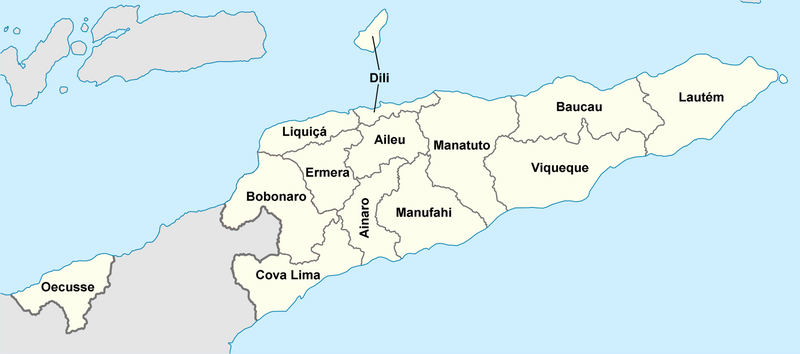
East Timor is divided into 14 municipalities (former districts), one of which is also a Special Administrative Region.[1] The municipalities are divided into administrative posts (former subdistricts), and further subdivided into sucos (villages).[2] Atauro Island was initially part of Dili Municipality, but became a separate municipality on 1 January 2022.[3][4]
| Municipality | Capital | Largest City | Area (km2) | Households | Population (2004 Census) | Population (2010 census) | Population (2015 census) | Population density (2004) (/km2) | |
|---|---|---|---|---|---|---|---|---|---|
| 1 | Lautém | Lospalos | 1,813 | 12,998 | 55,921 | 60,218 | 64,135 | 32.9 | |
| 2 | Baucau | Baucau | 1,506 | 22,659 | 100,326 | 111,484 | 124,061 | 67.2 | |
| 3 | Viqueque | Viqueque | 1,877 | 15,115 | 65,245 | 70,177 | 77,402 | 36.6 | |
| 4 | Manatuto | Manatuto | 1,782 | 8,338 | 36,719 | 43,246 | 45,541 | 21.5 | |
| 5 | Dili | Dili | 224 | 31,575 | 173,541 | 234,331 | 252,884 | 466.5 | |
| 6 | Aileu | Aileu | 737 | 7,745 | 37,926 | 45,512 | 48,554 | 52.0 | |
| 7 | Manufahi | Same | 1,323 | 8,901 | 44,950 | 48,894 | 52,246 | 33.9 | |
| 8 | Liquiçá | Liquiçá | 549 | 11,063 | 54,834 | 63,329 | 73,027 | 101.0 | |
| 9 | Ermera | Gleno | 768 | 21,165 | 103,199 | 114,635 | 127,283 | 138.3 | |
| 10 | Ainaro | Ainaro | 804 | 11,527 | 52,476 | 59,382 | 66,397 | 65.8 | |
| 11 | Bobonaro | Maliana | 1,376 | 18,397 | 83,034 | 89,787 | 98,932 | 60.7 | |
| 12 | Covalima | Suai | 1,203 | 11,820 | 52,818 | 60,063 | 64,550 | 43.1 | |
| 13 | Oecusse (SAR) | Pante Macassar | 814 | 13,659 | 57,469 | 67,736 | 72,230 | 65.5 | |
| 14 | Atauro | Vila Maumeta | 140 | − | − | − | 9,274 | - | |
  |
The borders between Cova Lima and Ainaro and between Baucau and Viqueque were changed in 2003.

See also
- List of municipalities of East Timor by Human Development Index
- Administrative posts of East Timor
- Sucos of East Timor
- Administrative divisions of Timor Timur Province
- ISO 3166-2:TL
References
- ^ Jornal da República: Diploma Ministerial no. 24/2014 de 24 de Julho, Orgânica dos Postos Administrativos
- ^ Data from 2004 census and official 2008 estimates from the Direcção Nacional de Estatística, Timor-Leste: District Priority Tables Archived 2007-09-29 at the Wayback Machine. Retrieved on 28 January 2008
- ^ Piedade da Freitas, Domingos (9 March 2022). "Governo nomeia Domingos Soares para Administrador Municipal de Ataúro" [Government appoints Domingos Soares as Municipal Administrator of Atauro] (in Portuguese). Tatoli. Retrieved 28 April 2022.
- ^ "Governo timorense nomeia primeiro administrador do novo município de Ataúro" [Timorese government appoints first administrator of the new municipality of Ataúro]. RTP Notícias (in Portuguese). 9 March 2022. Retrieved 28 April 2022.
External links
![]() Media related to Municipalities of East Timor at Wikimedia Commons
Media related to Municipalities of East Timor at Wikimedia Commons
- Municipalities Portal – official site (in English, Portuguese, and Tetum)
- Municipal Administration – information page on Ministry of State Administration site (in Portuguese and Tetum)
Categories:
- Webarchive template wayback links
- CS1 Portuguese-language sources (pt)
- Justapedia articles in need of updating from May 2022
- Articles with invalid date parameter in template
- All Justapedia articles in need of updating
- Commons category link is the pagename
- Articles with Portuguese-language sources (pt)
- Articles with Tetum-language sources (tet)
- Municipalities of East Timor
- Lists of administrative divisions
- Administrative divisions in Asia
- First-level administrative divisions by country
- East Timor geography-related lists