Mġarr
Mġarr
L-Imġarr | |
|---|---|
 View of Mġarr | |
|
Coat of arms of Mġarr Coat of arms | |
 | |
| Coordinates: 35°55′11″N 14°21′59″E / 35.91972°N 14.36639°ECoordinates: 35°55′11″N 14°21′59″E / 35.91972°N 14.36639°E | |
| Country | |
| Region | Northern Region |
| District | Northern District |
| Borders | Mellieħa, Mosta, Rabat, St. Paul's Bay |
| Government | |
| • Mayor | Paul Vella (PN) |
| Area | |
| • Total | 16.1 km2 (6.2 sq mi) |
| Population (Jan. 2019) | |
| • Total | 3,802 |
| • Density | 240/km2 (610/sq mi) |
| Demonym(s) | Mġarri (m), Mġarrija (f), Mġarrin (pl) |
| Time zone | UTC+1 (CET) |
| • Summer (DST) | UTC+2 (CEST) |
| Postal code | MGR |
| Dialing code | 356 |
| ISO 3166 code | MT-31 |
| Patron saint | St. Mary |
| Day of festa | 1st Sunday after 15 August |
| Website | Official website |
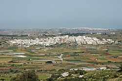
Mġarr (Maltese: L-Imġarr), formerly known as Mgiarro, is a village in the Northern Region of Malta. Mġarr is a typical rural village situated in an isolated region, west of Mosta. It is surrounded with rich farmland and vineyards. Many of its 3,629[1] inhabitants are farmers or are engaged in some sort of agricultural activity. Maltese pop singers Christabelle Borg and Gaia Cauchi both hail from this town.
History
Mġarr has two important prehistoric sites: Ta' Ħaġrat, which is still in a good state of preservation, stands in a field near the village centre; Ta' Skorba, excavated in 1963, lies just outside the village.
Mġarr's history is that of a farming community patronised by various of the Mdina patrician families. Mġarr was granted by the King of Sicily to the Inguanez family, and over time they sold it to the Falsone family. Over time, land was divided and given to all descendants.
Mġarr's rustic environs embrace rustic spots including Wardija, Fomm ir-Riħ, Għajn Tuffieħa and Ġnejna Bay.
San Anton School is a private school located in Mġarr.
Church
It was only at the beginning of the 20th century that Mġarr built its parish and the church was fully completed. The church has one of the largest domes in the world[citation needed], just behind the church of Mosta. The unique shape, that of an oval dome, is attributed to the extensive funds raised from the sale of more than 300,000 eggs.
The parish church of the Assumption of St. Mary is a miniature copy of the Mosta Dome. Its construction began in 1912 and depended on voluntary work and the generous contributions obtained by parishioners from the sale of agricultural products. Despite efforts to speed up the work, the church was not completed until 1946.
The church is located on high ground and its elevated parapet has a view of the surrounding fields and hills. In Mġarr there are still many houses surrounding the narrow streets around the church. Modern buildings and home ownership are new additions to the village.
Zones in Mġarr
- Abatija
- Ballut
- Binġemma
- Binġemma Gap
- Dar il-Ħamra
- Darrenzi
- Dwejra
- Fawwara
- Fomm ir-Riħ
- Ġnejna Bay
- Għajn Tuffieħa
- Għemieri
- Ħanxara
- Ħotba ta' San Martin
- Iċ-Ċagħaq
- Iċ-Ċarċar
- Id-Dahar
- Il-Għalqa
- L-Imselliet
- L-Iskorvit
- Lippija
- Misraħ Miet
- Ras il-Pellegrin
- Ras il-Wied
- Skorba
- Ta' Mrejnu
- Ta' Tewma
- Tal-Għajn
- Ta' Qarawas
- Tal-Faċċol
- Tal-Ħżejjen
- Tal-Palma
- Tal-Qanfud
- Tar-Ragħad
- Tas-Santi
- Wied Santi
- Wied tal-Ġnejna
- Wied tal-Imselliet
- Żebbiegħ
Notable people
- Myles Beerman (born 1999), professional footballer who plays as a defender for Rangers F.C.
- Christabelle Borg (born 1992), singer, represented Malta in the Eurovision Song Contest 2018
- Gaia Cauchi (born 2002), singer, won the Junior Eurovision Song Contest 2013
Twin towns – sister cities
 Mathi, Italy
References
- ^ "Estimated Population by Locality 31st March, 2014". Government of Malta. 16 May 2014. Archived from the original on 21 June 2015.
- ^ "Town twinning". mgarrlc.com. Mġarr. Retrieved 18 September 2019.
External links
![]() Media related to Mġarr at Wikimedia Commons
Media related to Mġarr at Wikimedia Commons
- Use dmy dates from February 2020
- Articles with short description
- Coordinates not on Wikidata
- Pages using infobox settlement with possible demonym list
- Articles containing Maltese-language text
- Articles needing additional references from October 2022
- All articles needing additional references
- All articles with unsourced statements
- Articles with unsourced statements from April 2022
- Commons category link is defined as the pagename
- AC with 0 elements
- Mġarr
- Towns in Malta
- Local councils of Malta
