Huatabampo
Huatabampo | |
|---|---|
 Seal | |
| Nickname: Tierra de generales | |
 Huatabampo  Huatabampo | |
| Coordinates: 27°3′N 109°25′W / 27.050°N 109.417°WCoordinates: 27°3′N 109°25′W / 27.050°N 109.417°W | |
| Country | |
| State | Sonora |
| Municipality | Huatabampo |
| Government | |
| • Municipal president | Juan Jesús Flores Mendoza |
| Population (2005) | |
| • Total | 76,296 |
| • Demonym | Huatabampense |
| Time zone | UTC-7 (Pacific (US Mountain)) |
| • Summer (DST) | UTC-7 (No DST) |
| Postal code | 85900- |
| Area code | 647 |
Huatabampo (Spanish pronunciation: [wataˈβampo]) is a city in Huatabampo Municipality in the state of Sonora, in northwestern Mexico. It is situated on the Gulf of California, near the mouth of the Mayo River. It is located at latitude 26°49′N 109°40′W / 26.817°N 109.667°W. Huatabampo is 34 km (21 mi) southwest of Navojoa via Sonora State Highway 56 and Sonora State Highway 149. Mexican Federal Highway 15 can be accessed via Sonora State Highway 176. It is notable as the home of revolutionary general Álvaro Obregón, a successful chickpea farmer before the Mexican Revolution, and now his burial site.
Etymology
The name Huatabampo is from the local Mayo language: "Huata" (Willow) + "Bampo" (Water), or "Willow in/near the Water".[1]
Huatabampo is also known as "Tierra de Generales" (Land of Generals) since during the Mexican Revolution (1910–1917) several high-ranking revolutionary generals emerged from the town.[2] Among them is Álvaro Obregón (1880–1928), who was born in Navojoa, but lived for many years in Huatabampo, the only undefeated general in the war. He was elected President of the Mexican Republic (1920–1924) after the war, being an important link between the war-devastated country and the first stages of political, economical and social development. He was assassinated in 1928 after his election to a second term, before he could take office. He is buried in the old local cemetery.
Other generals from the area were General José Tiburcio Otero Toledo (1834–1900), a famous military and a governor of Sonora, and General Ignacio Otero Pablos (1896–1970), who was Ambassador to the Dominican Republic and Venezuela and also a candidate for governor of Sonora.
Demographics
The population was 74,533 in 2005, with 29,789 inhabitants living in the municipal seat. Other towns are Ejido la Unión, Yavaros, Sahuaral de Otero, Etchoropo, Huatabampito, Moroncarit, Agiabampo, Estación Luis, Las Bocas, El Caro, Citavaro, Pozo Dulce, and El Júpare.
As of 2005 the per capita income for the municipality of Huatabampo was $5,984 and the Human Development Index was 0.8002. [3]
Economy
Huatabampo is a major agricultural producer for the area, its produce includes chickpeas as well as assorted fruit, vegetable and cereal crops. Cattle and swine raising is also very important.
Since Huatabampo has 120 km (75 mi) of coastline, fishing plays a major role in the economy. There are over 3,000 registered fishermen and around 20 open sea trawlers, in addition to almost 1,000 small boats. Shrimp raising has also become a major industry in recent years.
In 2000 there were 8 industries for industrialization of sardines, crab, and shrimp. The production of fish oil and fish flour is also important.
Tourism
The city attracts a considerable number of tourists, primarily from the United States, due to its beaches and spas.[citation needed]
Huatabampo is home to the Museum of Álvaro Obregón at the house of the revolutionary general and President of Mexico. His tomb is in the Old Cemetery.
Notable residents
- Álvaro Obregón
- General Ignacio Otero Pablos
- José Tiburcio Otero Toledo
- José Luis Ramírez
- Fernando Salas
- Baldomero "Mel" Almada
- Mario Almada
- Fernando Almada
- Daniel Duarte (baseball)
Government
Municipal presidents
| Municipal president | Term | Political party | Notes |
| Pedro H. Zubarrán[4] | 1899–1901 | ||
| Trinidad B. Rosas | 1907–1909 | ||
| José Tiburcio Otero | 1909–1911 | ||
| Álvaro Obregón | 1911–1912 | ||
| Benjamín Almada | 1913–1915 | ||
| Octavio Bojórquez | 1915–1917 | ||
| Bernardo J. Gastélum | 1917–1918 | ||
| Alejo Goycochea | 1918–1920 | ||
| Alfredo Goycochea | 1920–1921 | ||
| José Toledo | 1921–1922 | ||
| Rodolfo Ruiz Rábago | 1923 | ||
| Agustín Murillo | 1924–1925 | ||
| José Tiburcio Otero | 1925 | ||
| Federico Vázquez | 1925–1927 | ||
| Emilio Rosas | 1928 | ||
| Rodrigo Otero | 1930–1931 | PNR |
|
| Ramón F. Ibarra T. | 1932 | PNR |
Acting municipal president |
| Praxedis Gastélum | 1932–1935 | PNR |
|
| Antonio Encinas | 1935–1937 | PNR |
|
| Anastasio Barreras | 1937–1939 | PNR |
|
| Rodolfo Castro V. | 1939–1941 | PRM |
|
| Antonio Toledo | 1941–1943 | PRM |
|
| Abelardo Paredes | 1943–1946 | PRM |
|
| Ignacio Valderráin | 1946–1949 | PRI |
|
| N/A | 1949–1952 | ||
| Alfredo Santini E. | 1952–1955 | PRI |
|
| Jesús Ibarra R. | 1955–1958 | PRI |
|
| Víctor M. Romo | 1958–1961 | PRI |
|
| Alfredo Káram M. | 1961–1964 | PRI |
|
| Martín Larrauri G. | 1964–1965 | PRI |
|
| Arnoldo Ahumada B. | 1965–1967 | PRI |
|
| Próspero M. Ibarra | 1967–1970 | PRI |
|
| Francisco Rosas Ibarra | 1970–1973 | PRI |
|
| Manuel Castro T. | 1973–1976 | PRI |
|
| Arturo Siqueiros S. | 1976–1979 | PRI |
|
| Rodolfo Moreno G. | 1979–1982 | PRI |
|
| Roberto Rosas T. | 1982–1985 | PRI |
|
| Germán Bleizeffer Luis | 1985–1988 | PRI |
|
| Heliodoro Soto Rodríguez | 1988–1991 | PRI |
|
| Luis Alberto Ibarra Guerra[5] | 1991–1994 | PRI |
|
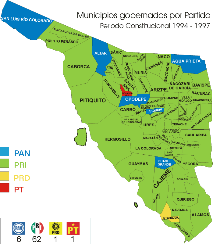
| Bleizeffer Vega[6][7] | 1994–1997 | PRI |
|
| Francisco García Cancino[8] | 1997–2000 | PRD |
|
| Daniel Ibarra Guerra[9] | 2000–2003 | PRI |
|
| Juan José Lam Angulo[10][11] | 16-09-2003–15-09-2006 | PRD PAS Convergence |
|
| César Bleizeffer Vega[12][13] | 16-09-2006–15-09-2009 | PAN |
|
| Próspero Manuel Ibarra Otero[14] | 16-09-2009–15-09-2012 | PRI PVEM Panal |
|
| Ramón Antonio Díaz Nieblas[15] | 16-09-2012–15-09-2015 | PAN Panal |
|
| Heliodoro Soto Olguín[16] | 16-09-2015–15-09-2018 | PRI PVEM Panal |
Coalition "For an Honest and Effective Government" |
| Ramón Antonio Díaz Nieblas[17] | 16-09-2018–15-09-2021 | PAN PRD |
Coalition "For Sonora to the Front" |
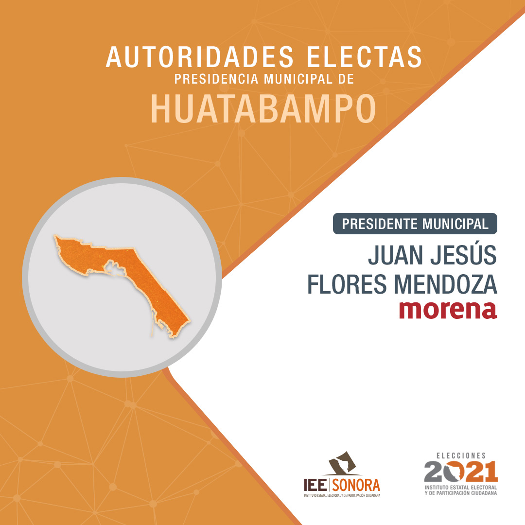
| Juan Jesús Flores Mendoza[18] | 16-09-2021– | Morena |
External links
- Huatabampo, Ayuntamiento Digital (Official Website of Huatabampo, Sonora)
References
- Enciclopedia de los Municipios de México (INAFED)
- INEGI
- The official site of Huatabampo With pictures and information
- Sonora Turismo
- Wikimapia satellite view
- Map of Sonora
- ^ "Your gateway to Sonoran Adventures".
- ^ "Enciclopedia de los Municipios y Delegaciones de México. Sonora. Huatabampo".
- ^ Oficina Nacional de Desarrollo Humano (2005). "IDH Municipal 2000-2005 base de datos". Archived from the original on 2009-03-06. Retrieved 2008-12-17.
- ^ "Enciclopedia de los Municipios y Delegaciones de México. Sonora. Huatabampo" (in Spanish). Retrieved 31 October 2021.
- ^ "Municipios gobernados por partido político. Período constitucional 1991-1994" (PDF) (in Spanish). Retrieved 31 October 2021.
- ^ "Resultados oficiales. Proceso electoral 1994. Huatabampo. PRI: 16276 votos. PRD: 8879 votos. PAN: 4226 votos. Partido del Frente Cardenista de Reconstrucción Nacional (PFCRN): 516 votos. Partido Popular Socialista (PPS): 176 votos" (in Spanish). Retrieved 31 October 2021.
- ^ "Mapa de municipios gobernados por partido. Período constitucional 1994–1997" (in Spanish). Retrieved 31 October 2021.
- ^ "Municipios gobernados por partido político. Período constitucional 1997-2000" (PDF) (in Spanish). Retrieved 31 October 2021.
- ^ "Consejo Electoral del Estado de Sonora. Conformación de Ayuntamientos. 2000" (PDF) (in Spanish). Retrieved 31 October 2021.
- ^ "Resultados oficiales de la elección de Ayuntamientos. 2003. Huatabampo: PRD-Partido Alianza Social (PAS)-Convergencia: 10606 votos. PRI: 10438 votos. PAN: 7140 votos. PT: 205 votos" (PDF) (in Spanish). Retrieved 31 October 2021.
- ^ "Municipios gobernados por partido político. Período constitucional 2003-2006" (PDF) (in Spanish). Retrieved 31 October 2021.
- ^ "Consejo Electoral del Estado de Sonora. Conformación de Ayuntamientos. 2006" (PDF) (in Spanish). Retrieved 31 October 2021.
- ^ "Municipios gobernados por partido políticos. Período constitucional 2006-2009" (PDF) (in Spanish). Retrieved 31 October 2021.
- ^ "Consejo Electoral del Estado de Sonora. Conformación de Ayuntamientos. 2009" (PDF) (in Spanish). Retrieved 31 October 2021.
- ^ "Consejo Electoral del Estado de Sonora. Conformación de planillas de Ayuntamiento. 2012" (PDF) (in Spanish). Retrieved 31 October 2021.
- ^ "Instituto Electoral y de Participación Ciudadana de Sonora. Conformacion de planillas de Ayuntamiento. 2015" (PDF) (in Spanish). Retrieved 31 October 2021.
- ^ "Instituto Electoral y de Participación Ciudadana de Sonora. Cómputo municipal. Período constitucional 2018-2021. Huatabampo. PAN-PRD: 11857 votos. PT-Morena-PES: 8185 votos. PRI-PVEM-Panal: 7938 votos" (PDF) (in Spanish). Retrieved 31 October 2021.
- ^ "Instituto Estatal Electoral y de Participación Ciudadana de Sonora (IEESonora). Autoridades electas. Presidencia Municipal de Huatabampo" (in Spanish). Retrieved 31 October 2021.
