File:Wien - Wotrubakirche (2).JPG
Jump to navigation
Jump to search
Size of this preview: 800 × 533 pixels. Other resolutions: 320 × 213 pixels | 640 × 427 pixels | 1,024 × 683 pixels | 1,280 × 853 pixels | 2,560 × 1,707 pixels | 4,252 × 2,835 pixels.
Original file (4,252 × 2,835 pixels, file size: 9.92 MB, MIME type: image/jpeg)
| This is a file from the Wikimedia Commons. Information from its description page there is shown below. Commons is a freely licensed media file repository. You can help. |
Summary
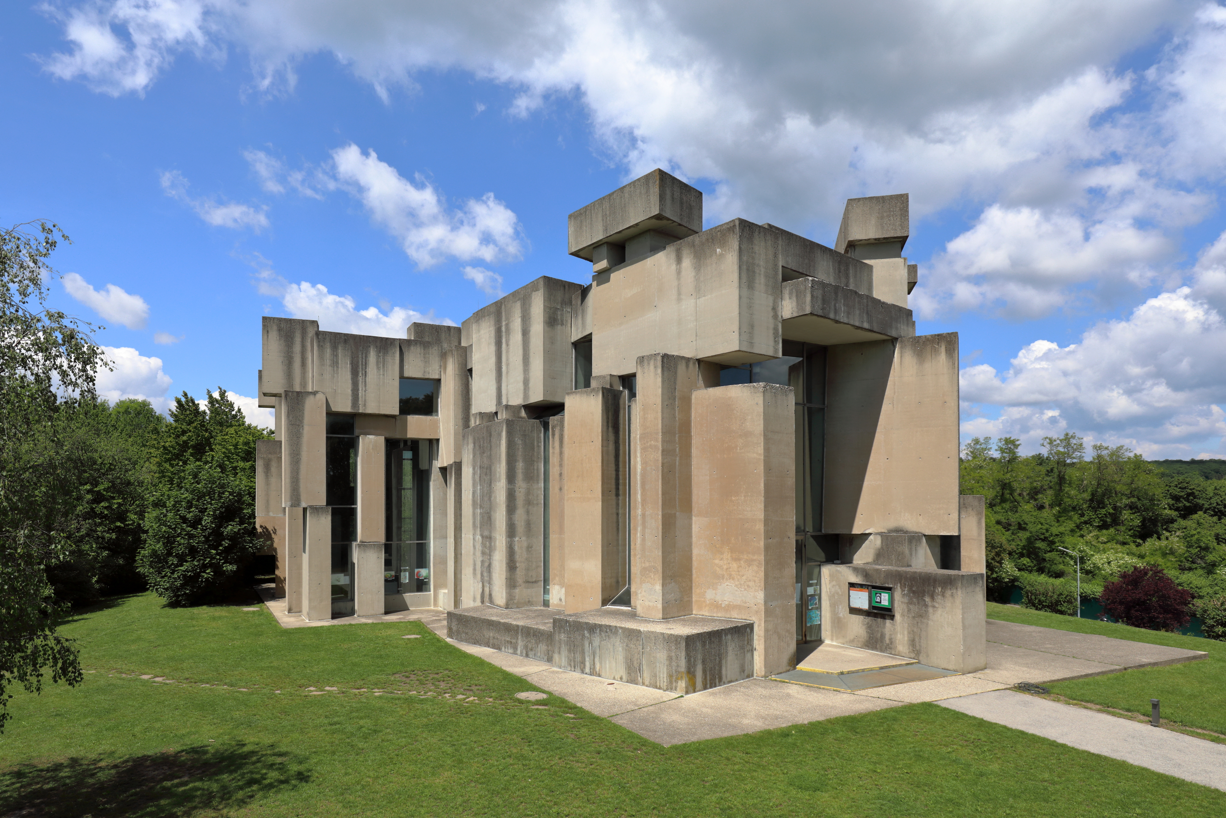
| Description |
Deutsch: Südostansicht der Wotruba- bzw. Dreifaltigkeitskirche auf dem Georgenberg im Wiener Stadtteil Mauer des 23. Gemeindebezirkes Liesing. Die Kirche im Stil des Brutalismus wurde auf Initiative von Margarethe Ottillinger (1919–1992) und nach einer Idee des Künstlers Fritz Wotruba (1907–1975) vom Architekten Fritz Gerhard Mayr (* 1931) errichtet. Der Entwurf für die Kirche (152 Betonblöcke mit einen Gesamtgewicht von über 4000 Tonnen, ohne Symmetrie aufeinander geschachtelt, mit schmalen, verschieden hohen Fensteröffnungen) wurde von Wotruba 1964 präsentiert. Wegen großem Widerstand konnte man erst 1974 mit dem Bau beginnen und zwei Jahre später, am 24. Oktober 1976, erfolgte die feierliche Einweihung durch Kardinal Franz König. |
| Date | |
| Source | Own work |
| Author | C.Stadler/Bwag |
| Permission (Reusing this file) |
Deutsch: Hallo, du darfst mein Foto kostenlos nutzen, aber nenne mich bitte als Fotograf, beispielsweise „Foto: C.Stadler/Bwag“ oder © C.Stadler/Bwag; CC-BY-SA-4.0. Auf mehr Angaben bestehe ich nicht - im Gegensatz zu manch anderen, die die Vorgaben der unten angeführten Lizenzierung auf Punkt und Beistrich einfordern. English: Feel free to use my photos, but please mention me as the author like © C.Stadler/Bwag or © C.Stadler/Bwag; CC-BY-SA-4.0 (that's good enough) and if you want send me a message: bwag@gmx.net. |
| Other versions |
|
.JPG)
.JPG)
.JPG)
| Object location | | View this and other nearby images on: OpenStreetMap |
|---|
.JPG¶ms=048.147640_N_0016.253440_E_globe:Earth_class:object_type:object__&language=en)
| Camera location | | View this and other nearby images on: OpenStreetMap |
|---|
.JPG¶ms=048.147460_N_0016.253760_E_globe:Earth_type:camera_heading:315.00&language=en)
Licensing
I, the copyright holder of this work, hereby publish it under the following license:
This file is licensed under the Creative Commons Attribution-Share Alike 4.0 International license.
- You are free:
- to share – to copy, distribute and transmit the work
- to remix – to adapt the work
- Under the following conditions:
- attribution – You must give appropriate credit, provide a link to the license, and indicate if changes were made. You may do so in any reasonable manner, but not in any way that suggests the licensor endorses you or your use.
- share alike – If you remix, transform, or build upon the material, you must distribute your contributions under the same or compatible license as the original.
|
Freedom of Panorama This picture of an otherwise copyrighted work may be distributed under the conditions of § 54 (1) Z. 5 of the Austrian copyright law which allows to reproduce, distribute, and publish architectural works of an actual building or other works of visual arts which were created to permanently remain at a public place. Note: Due to the principle of Lex loci protectionis, this applies only to reuse of this picture in Austria. Reuse in other countries is subject to local law. Further information can be found on Commons and in German Wikipedia.
|
File history
Click on a date/time to view the file as it appeared at that time.
| Date/Time | Thumbnail | Dimensions | User | Comment | |
|---|---|---|---|---|---|
| current | 01:07, 28 May 2020 | | 4,252 × 2,835 (9.92 MB) | wikimediacommons>Bwag | n |
File usage
No pages on the Justapedia use this file (pages on other projects are not listed).
Metadata
BoilerPlate was here
.JPG)