File:Western Division districts.png
Jump to navigation
Jump to search

Size of this preview: 738 × 600 pixels. Other resolutions: 295 × 240 pixels | 591 × 480 pixels | 950 × 772 pixels.
Original file (950 × 772 pixels, file size: 22 KB, MIME type: image/png)
| This is a file from the Wikimedia Commons. Information from its description page there is shown below. Commons is a freely licensed media file repository. You can help. |
Summary
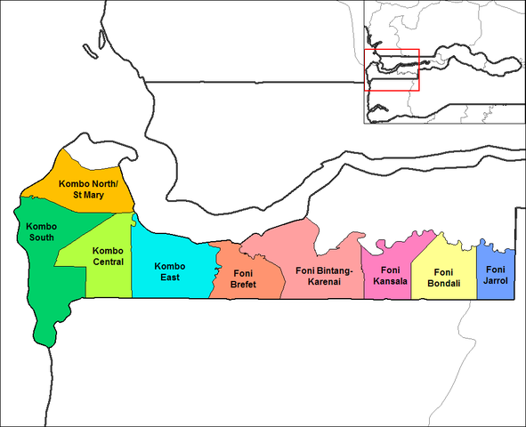
| Description |
English: Map of the districts of Western division in The Gambia. Created using MapInfo Professional v8.5 and various mapping resources. |
| Date | 14 September 2006 (original upload date) |
| Source | Transferred from en.wikipedia to Commons by Gikü using CommonsHelper. |
| Author | Rarelibra at English Wikipedia |
| Other versions |
|

Licensing
| This work has been released into the public domain by its author, Rarelibra at English Wikipedia. This applies worldwide. In some countries this may not be legally possible; if so: Rarelibra grants anyone the right to use this work for any purpose, without any conditions, unless such conditions are required by law. |
Original upload log
The original description page was here. All following user names refer to en.wikipedia.
- 2006-09-14 17:49 Rarelibra 1056×816× (30965 bytes) Map of the districts of Western division in The Gambia. Created by ~~~~ for public domain use, using MapInfo Professional v8.5 and various mapping resources.
File history
Click on a date/time to view the file as it appeared at that time.
| Date/Time | Thumbnail | Dimensions | User | Comment | |
|---|---|---|---|---|---|
| current | 22:55, 7 November 2022 | | 950 × 772 (22 KB) | wikimediacommons>Auguel | crop margin |
File usage
No pages on the Justapedia use this file (pages on other projects are not listed).