File:Taiwan ROC political division map New Taipei City.svg
Jump to navigation
Jump to search

Size of this PNG preview of this SVG file: 425 × 600 pixels. Other resolutions: 170 × 240 pixels | 340 × 480 pixels | 544 × 768 pixels | 725 × 1,024 pixels | 1,451 × 2,048 pixels | 850 × 1,200 pixels.
Original file (SVG file, nominally 850 × 1,200 pixels, file size: 119 KB)
| This is a file from the Wikimedia Commons. Information from its description page there is shown below. Commons is a freely licensed media file repository. You can help. |
Summary
| Description |
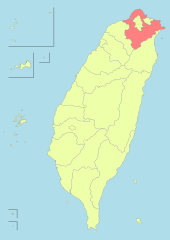
English: New Taipei, formerly Taipei County. 中文(臺灣):新北市,原為台北縣。 閩南語 / Bân-lâm-gú:Sin-pak-tshī, tsìn-tsiân sī Tâi-pak-kuān. 新北市,進前是臺北縣。 Українська: Новий Тайбей, Тайвань
Русский: Новый Тайбэй, Тайвань |
| Date | |
| Source | File:Taiwan ROC political division map Kaohsiung City (2010).svg |
| Author | ASDFGHJ |
.svg)
Licensing
I, the copyright holder of this work, hereby publish it under the following license:
This file is licensed under the Creative Commons Attribution-Share Alike 3.0 Unported license.
- You are free:
- to share – to copy, distribute and transmit the work
- to remix – to adapt the work
- Under the following conditions:
- attribution – You must give appropriate credit, provide a link to the license, and indicate if changes were made. You may do so in any reasonable manner, but not in any way that suggests the licensor endorses you or your use.
- share alike – If you remix, transform, or build upon the material, you must distribute your contributions under the same or compatible license as the original.
File history
Click on a date/time to view the file as it appeared at that time.
| Date/Time | Thumbnail | Dimensions | User | Comment | |
|---|---|---|---|---|---|
| current | 14:56, 2 January 2011 | | 850 × 1,200 (119 KB) | wikimediacommons>Meow | Updated. |
File usage
No pages on the Justapedia use this file (pages on other projects are not listed).
BoilerPlate was here