File:TWA Transcontinental Routes and Map 1933.jpg
Jump to navigation
Jump to search
Size of this preview: 800 × 595 pixels. Other resolutions: 320 × 238 pixels | 640 × 476 pixels | 1,024 × 761 pixels | 1,280 × 952 pixels | 2,560 × 1,904 pixels | 3,534 × 2,628 pixels.
Original file (3,534 × 2,628 pixels, file size: 10.27 MB, MIME type: image/jpeg)
| This is a file from the Wikimedia Commons. Information from its description page there is shown below. Commons is a freely licensed media file repository. You can help. |
Summary
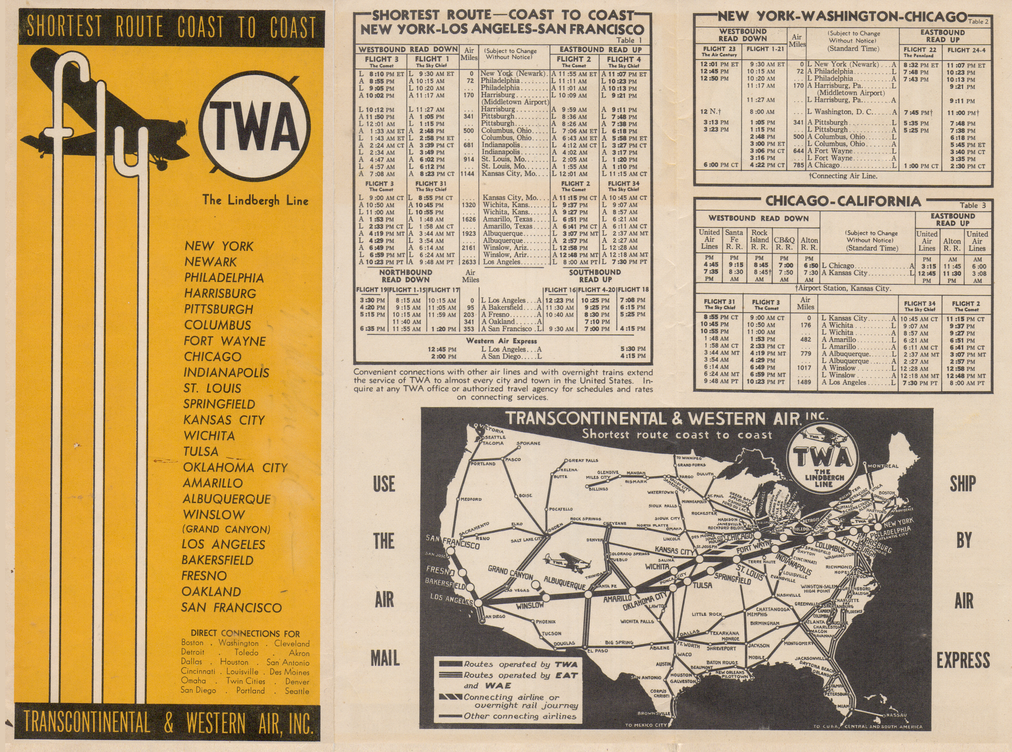
| Description | Transcontinental & Western Air (TWA) coast-to-coast routes and route map |
| Date | September 1, 1933 (Time table) |
| Source | Uploader's collect |
| Author | Transcontinental & Western Air. Inc |
Licensing
This work is in the public domain in the United States because it was published in the United States between 1929 and 1977, inclusive, without a copyright notice. For further explanation, see Commons:Hirtle chart as well as a detailed definition of "publication" for public art. Note that it may still be copyrighted in jurisdictions that do not apply the rule of the shorter term for US works (depending on the date of the author's death), such as Canada (50 p.m.a.), Mainland China (50 p.m.a., not Hong Kong or Macao), Germany (70 p.m.a.), Mexico (100 p.m.a.), Switzerland (70 p.m.a.), and other countries with individual treaties.
|
 |
File history
Click on a date/time to view the file as it appeared at that time.
| Date/Time | Thumbnail | Dimensions | User | Comment | |
|---|---|---|---|---|---|
| current | 02:35, 17 May 2020 | | 3,534 × 2,628 (10.27 MB) | wikimediacommons>Centpacrr | {{Information |description=Transcontinental & Western Air (TWA) coast-to-coast routes and route map |date=September 1, 1933 (Time table) |source=Uploader's collect |author=Transcontinental & Western Air. Inc |permission= |other versions= }} |
File usage
No pages on the Justapedia use this file (pages on other projects are not listed).