File:Sudetenland Reichsgau 1944.png
Jump to navigation
Jump to search

Size of this preview: 799 × 342 pixels. Other resolutions: 320 × 137 pixels | 640 × 274 pixels | 1,024 × 438 pixels | 1,280 × 548 pixels | 4,653 × 1,992 pixels.
Original file (4,653 × 1,992 pixels, file size: 1.15 MB, MIME type: image/png)
| This is a file from the Wikimedia Commons. Information from its description page there is shown below. Commons is a freely licensed media file repository. You can help. |
Summary
| Description |
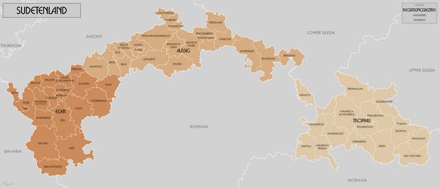
English: Administrative map of Reichsgau Sudetenland in 1944. Source
GIS Data digitised from Karte des Deutschen Reiches 1:100 000 and Karte von Mitteleuropa 1:300k. Some source maps from WIG (www.mapywig.org). |
| Date | |
| Source | Own work |
| Author | XrysD |
Licensing
I, the copyright holder of this work, hereby publish it under the following license:
This file is licensed under the Creative Commons Attribution-Share Alike 3.0 Unported license.
- You are free:
- to share – to copy, distribute and transmit the work
- to remix – to adapt the work
- Under the following conditions:
- attribution – You must give appropriate credit, provide a link to the license, and indicate if changes were made. You may do so in any reasonable manner, but not in any way that suggests the licensor endorses you or your use.
- share alike – If you remix, transform, or build upon the material, you must distribute your contributions under the same or compatible license as the original.
File history
Click on a date/time to view the file as it appeared at that time.
| Date/Time | Thumbnail | Dimensions | User | Comment | |
|---|---|---|---|---|---|
| current | 14:40, 13 January 2024 | | 4,653 × 1,992 (1.15 MB) | wikimediacommons>XrysD | Mistake in boundary of kreise Grulich corrected |
File usage
No pages on the Justapedia use this file (pages on other projects are not listed).